 UpToWhere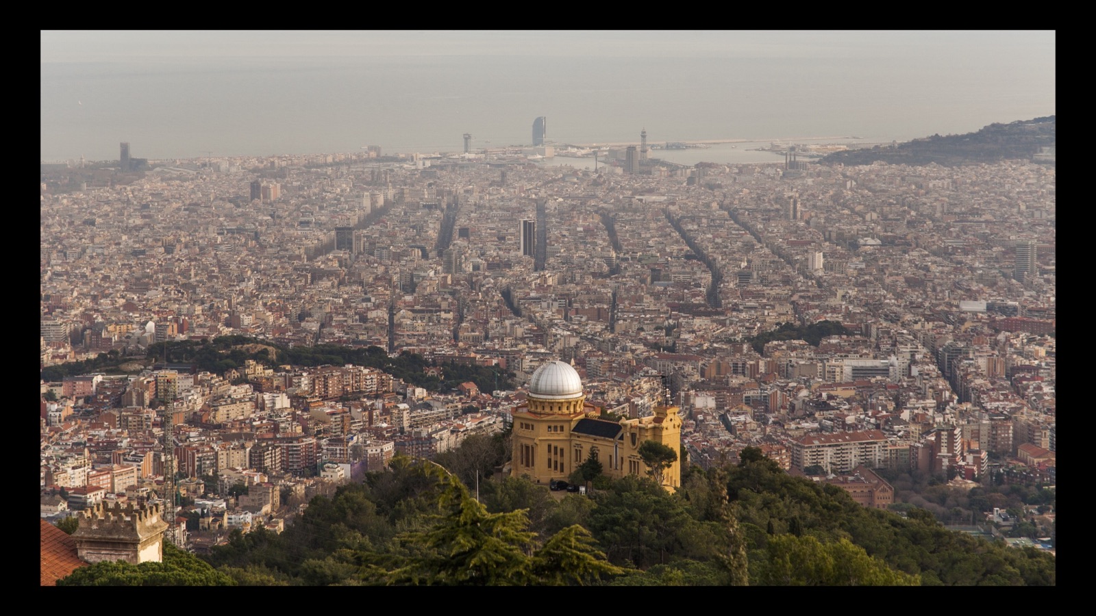
Photo: Doc Searls, CC BY 2.0, via Wikimedia Commons.

On certain cold November mornings, people standing on Barcelona's hills photograph a jagged blue silhouette floating on the sea horizon to the south-southeast, backlit by the low dawn sun. The silhouette is the Serra de Tramuntana, the mountain spine of Mallorca, about 190 km away. Every time one of these photos circulates, the same argument starts underneath it. A lot of the city simply does not believe it. The photographer who has documented the sightline most carefully, Marc Bret, wrote after one of his own sightings that "despite this sightings a large ammount of citizens from Barcelona still don't believe Mallorca can actually be seen from its city."
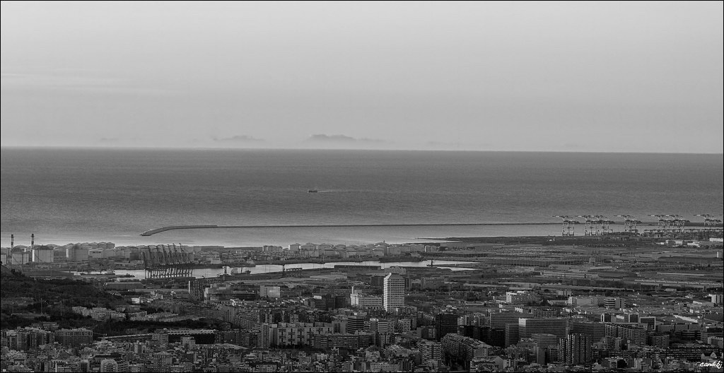
Photo: candi… on Flickr, CC BY 2.0.
And on the very best mornings the apparition needs no squinting at all. In December 2023 the Fabra Observatory's meteorologist, Alfons Puertas, caught the whole Tramuntana in crisp silhouette against the dawn, floating over the lights of Barcelona's port:
The disbelief got international help a few weeks before that tweet, in November 2023, when Puertas photographed Mallorca at dawn from the same terrace and the press reported the image as one that "defies science", on the reasoning that Earth's curvature should hide the island entirely. The only explanation on offer was a tweet gesturing at "atmospheric refraction."
Nobody in that argument had run the terrain. So we did, at the highest resolution we could make the geometry hold: 19 full sweeps of 40,001 sightlines each, every ray walked end to end at 10 metre steps across the 30 m Copernicus elevation model, about 19 billion terrain samples for the island window alone, plus a 144,000-ray sweep of Barcelona's entire 360° horizon.
The short version: the believers are right, the sceptics have the physics backwards, and the island turns out to be a much larger presence on Barcelona's horizon than either camp assumes.
From Tibidabo, the whole range clears the horizon
Start from the city's classic high point, the 512 m summit of Tibidabo, where Bret took his 184–193 km photographs in November 2014. Under standard refraction (the textbook coefficient for ordinary air, k = 0.13), with no anomaly of any kind, this is what stands above the sea horizon:
| Summit | Height | Distance | Stands above the horizon ray |
|---|---|---|---|
| Puig Major | 1,436 m | 188.2 km | +736 m |
| Penya de Migdia | 1,356 m | 188.5 km | +668 m |
| Puig de Massanella | 1,365 m | 189.9 km | +629 m |
| Puig Tomir | 1,103 m | 188.2 km | +399 m |
| Puig des Tossals Verds | 1,118 m | 191.4 km | +367 m |
| Puig de sa Rateta | 1,113 m | 191.5 km | +364 m |
| Puig Roig | 1,003 m | 184.4 km | +349 m |
| Puig de l'Ofre | 1,093 m | 192.2 km | +322 m |
| Serra d'Alfàbia | 1,067 m | 193.5 km | +288 m |
| Es Teix | 1,064 m | 194.0 km | +220 m |
| Puig Galatzó | 1,027 m | 201.0 km | +124 m |
Heights are the published summit figures; the clearances are computed on the elevation model's own summit cells, which run 5 to 40 m lower, as a 30 m grid does on a sharp peak.
Eleven summits, and that is only the ones with names worth listing. This is not a marginal, one-peak-pokes-through situation: Puig Major stands three quarters of a kilometre above the line, and even Galatzó, the far south-western outlier at 201 km, has 124 m of air under it. The two peaks that genuinely do not make it, Puig de ses Vinyes and Puig de ses Bassetes, are hidden by the Tramuntana's own front wall rather than by the curve of the Earth.
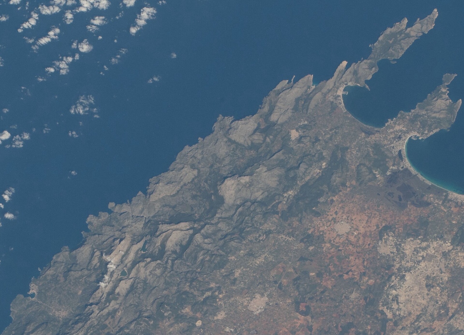
Photo: NASA, ISS064-E-406, public domain, via Wikimedia Commons.
.jpg)
Scoring named summits is one thing. The 40,001-ray sweep draws the actual shape:
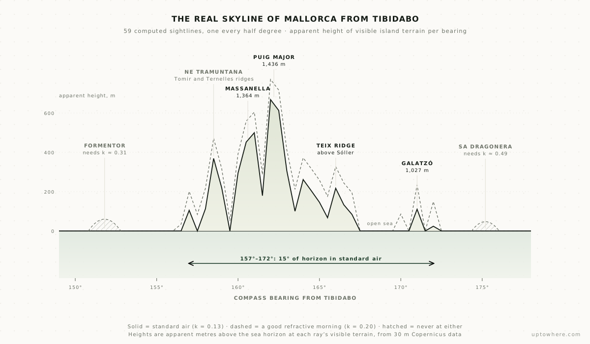
The island occupies 15.464° of horizon, from bearing 156.543° to 172.007°, but only 10.657° of that is actually island. The other 4.8° is open sea showing through the gaps. It arrives in eight separate pieces, the largest being a single unbroken 5.784° wall running from Massanella across Puig Major.
That fragmentation is exactly what a coarse sweep destroys. Sampled every half degree, the same terrain returns four fragments instead of eight: Tomir merges into the main wall and the Galatzó group's structure disappears completely. The count only stabilises at about a tenth of a degree, and everything finer than that just smooths the line. The folk description was right all along, and Bret's post says it plainly: the mountains appear "discontinuously, with some mountains separated between them by the sea." The widest of those sea gaps, between the Alfàbia ridge and the Son Serralta group, is 2.33° of open water.
The sea is not the obstacle. The island is
Here is the counterintuitive part. From Tibidabo, the sightline to Puig Major clears the open sea with hundreds of metres to spare. What limits the view is Mallorca itself, and the horizon ray's own height when it gets there.
The ray cuts the island somewhere between 628 m and 896 m, depending on the bearing, with a median of 695 m. Everything below that, the ports, the towns, nearly the entire coastline, stays buried behind the curve of the sea, while the crests above it stand clear. So the image that reaches Barcelona is a horizontal slice: the upper part of a mountain range, floating with no visible base.
The lowest point of that cut is not where the eye expects it, which would be the tall sea cliffs below Puig Major. It is on the northern coast near Cala Sant Vicenç, a kilometre from Punta de la Sal, at 628 m. Not because that coast is higher, but because it is nearer: 183.0 km instead of 188. Five kilometres of distance is worth about 70 m of altitude out there, which is why the closest corner of the island, not the tallest, is the one that reaches furthest down.
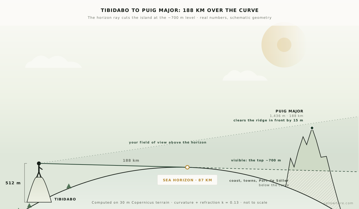
Our article on how much the horizon hides walks through that arithmetic for any distance.
Barcelona sees 0.62% of Mallorca
Because the rays land 3.3 m apart when they reach the island, finer than the terrain model itself, the sweep does not just give a silhouette. It gives a map of every square metre of Mallorca that Barcelona can see.
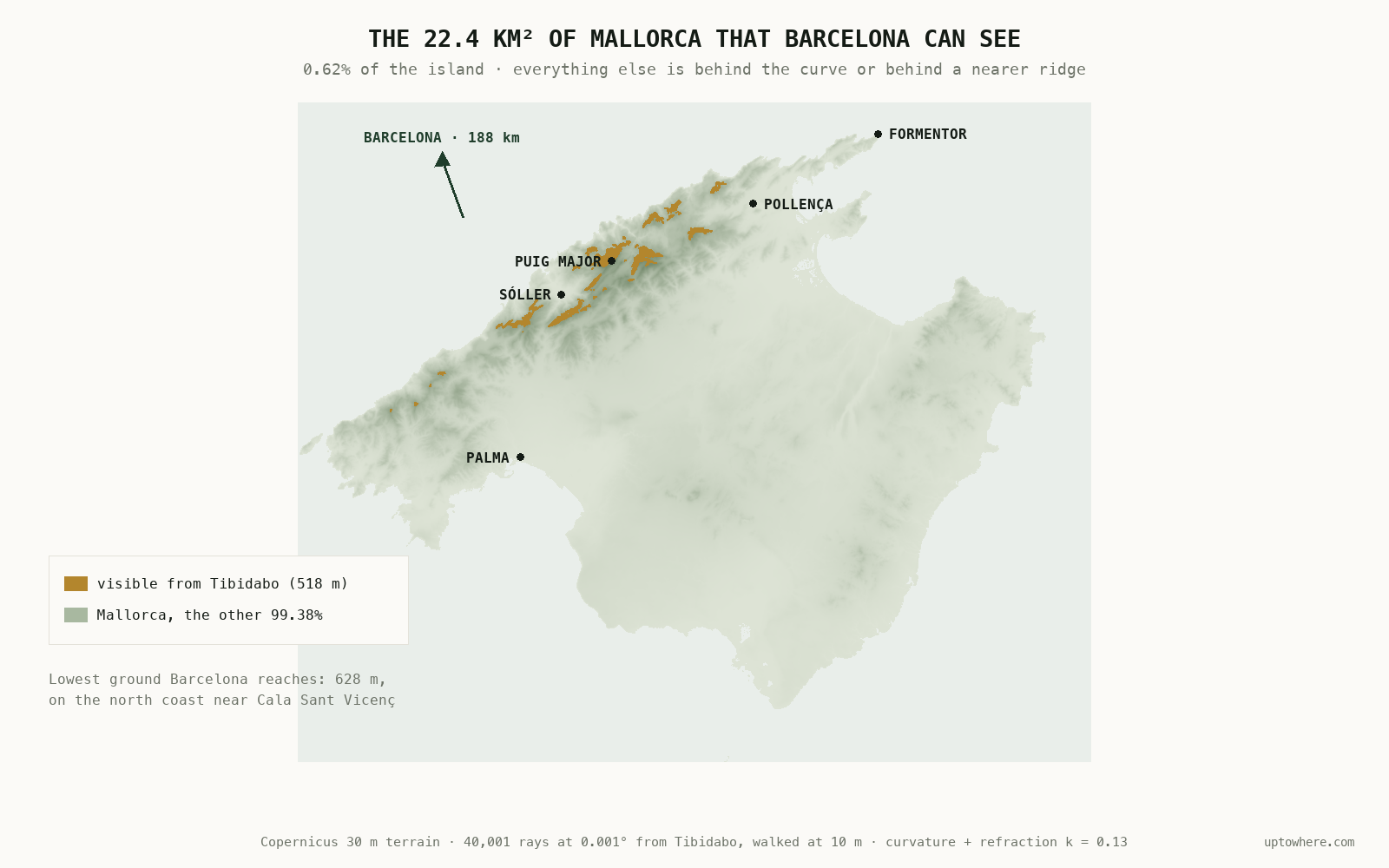
22.4 km² out of 3,596. Nought point six two per cent, and all of it ridge crest.
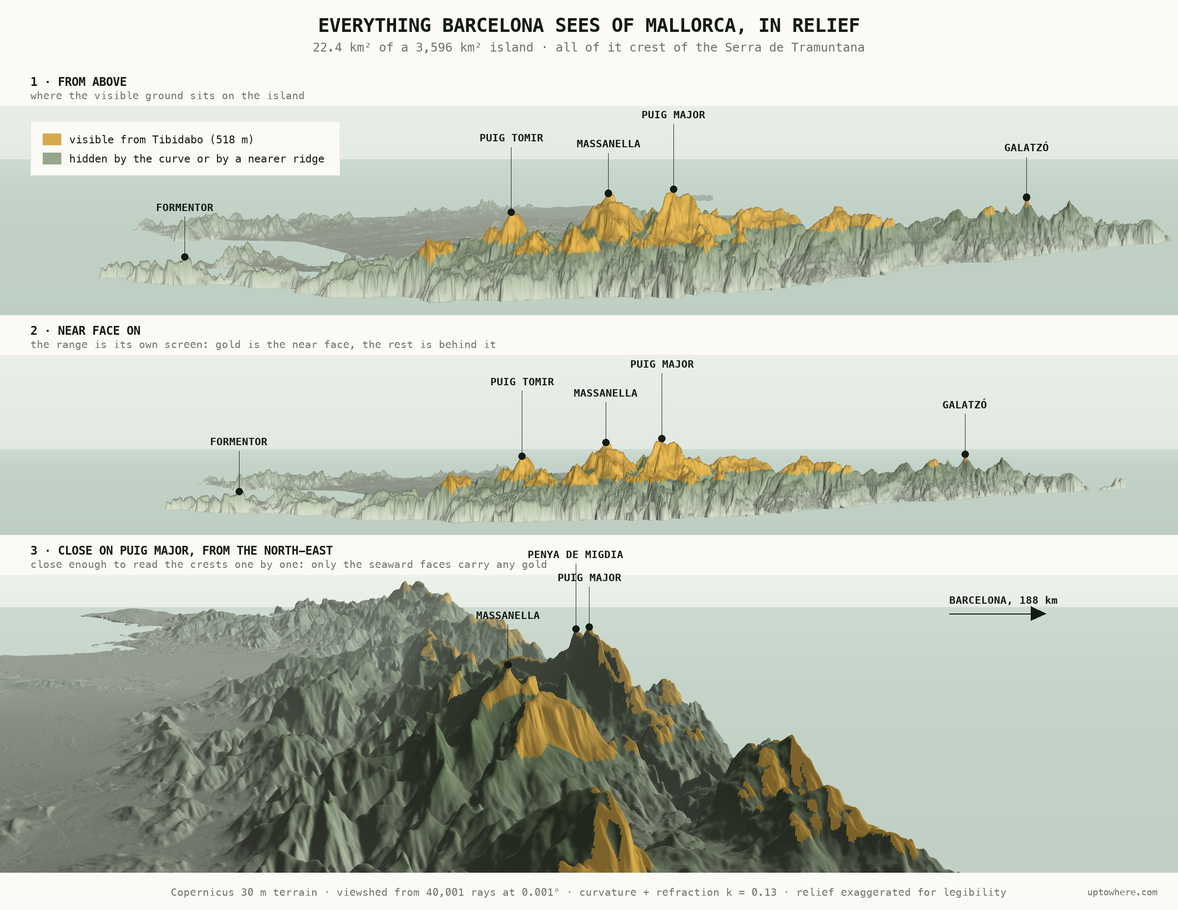
Seen in relief from Barcelona's own bearing, the pattern is obvious: the gold is the seaward wall of the Tramuntana and nothing else. The range is its own screen. Behind it the island falls away into a plain that has never been visible from the mainland and never will be.
Height alone does not buy you a place on that map either. Of the 163.5 km² of Mallorca that sits above Tibidabo's lowest visible altitude, only 13.7% is actually visible; the rest is high enough but stands behind something nearer.
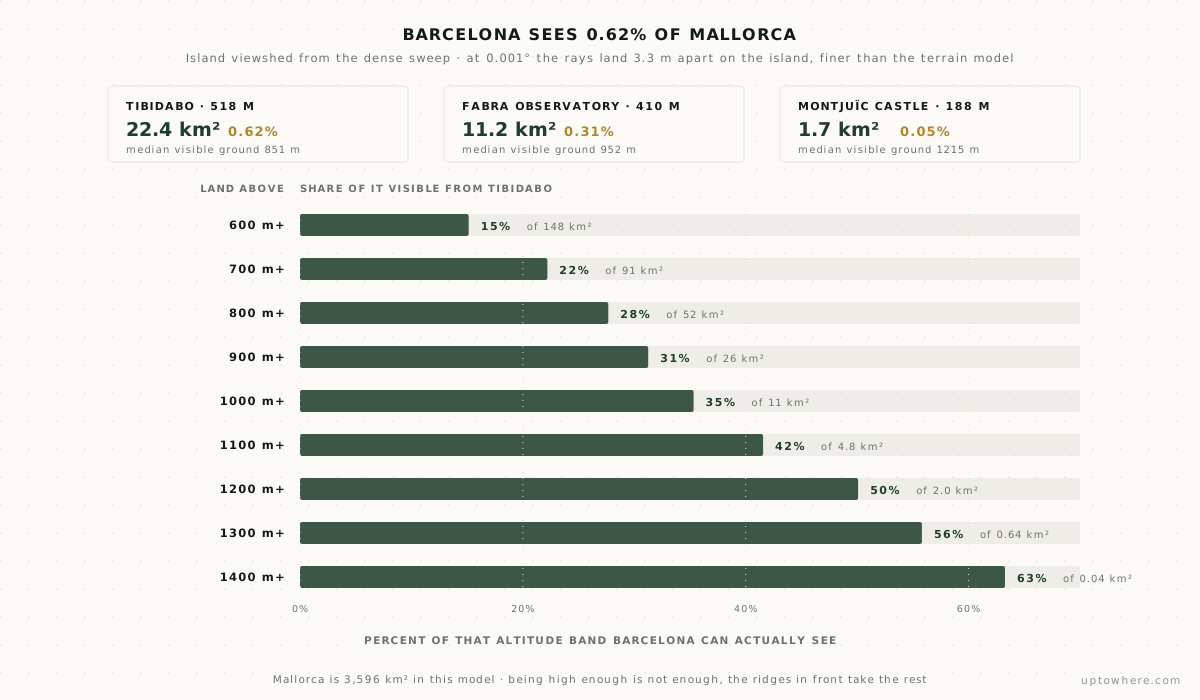
Drop 108 m to the Fabra Observatory and the island's visible area halves, to 11.2 km². Drop to Montjuïc and it collapses to 1.7 km², a twentieth of a per cent, three summit caps and nothing else.
How low can you stand and still see it?
Tibidabo is comfortable. The interesting question is the threshold, and the folk claims are surprisingly specific. Bret reported seeing the island from just 95 m up on Montjuïc, and referenced another observer's sighting from 52 m under "exceptional refraction."
So we searched for the threshold directly, bisecting the observer's height to the centimetre at every one of 4,001 bearings from the Barceloneta seafront. The answer is 93.85 m. But a single number hides what is really going on, which is that most of that stretch of horizon is out of reach from anywhere in the city:
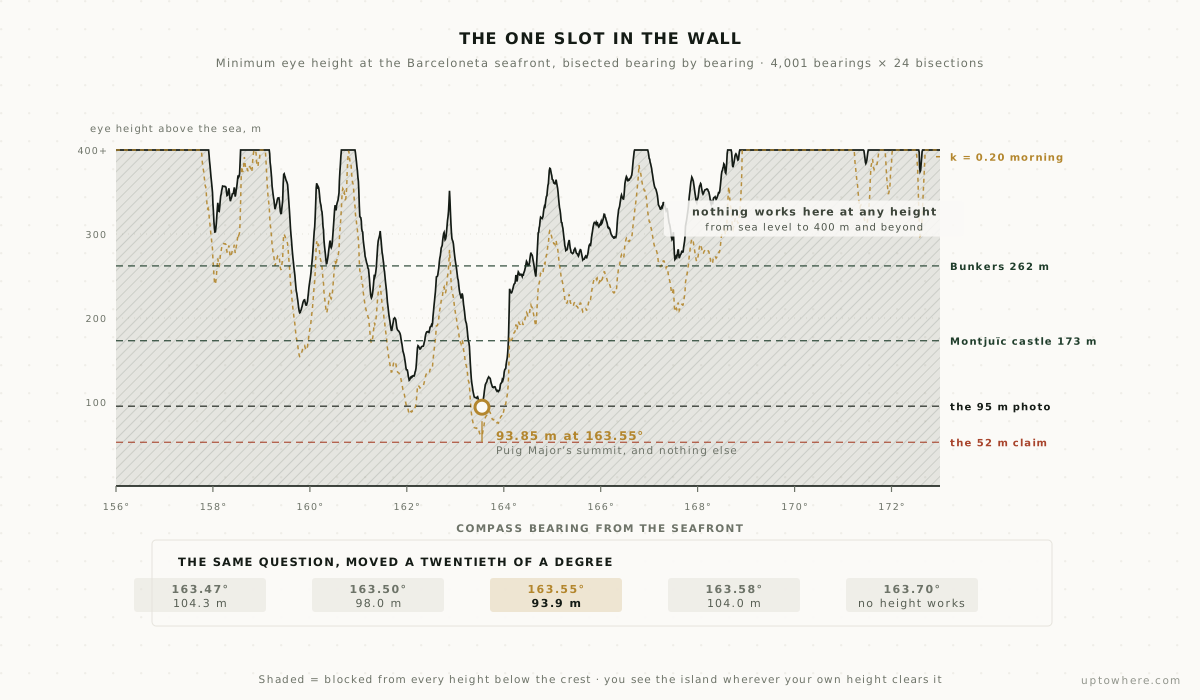
Every refraction value puts the minimum on the same bearing, 163.55°, which is Puig Major's summit and nothing else. Step a twentieth of a degree either side and the requirement jumps ten metres. Step a fifth of a degree and no height works at all. Whether Barcelona can see Mallorca at minimum altitude comes down to a single narrow slot in the sky.
Now put the folk claims against it:
- The 95 m sighting works, with 1.2 m to spare. The lowest documented observation of Mallorca from Barcelona sits almost exactly on the computed geometric threshold. Bret was not exaggerating his luck.
- The 52 m claim needs k = 0.218, about seventy percent more bend than standard air. That is a strong but entirely real condition, the kind cold mornings over a warm sea produce. The claimant called it exceptional refraction, and the number agrees with the adjective.
- A point on Montjuïc's seaward slope at 86 m just misses: k = 0.145 tips it over, a whisker above standard. On that slope, on any slightly favourable morning, the summit is there.
- From the beach itself it never really works. You would need k ≈ 0.37, which is not bent air but a duct, a distinct and much rarer phenomenon.
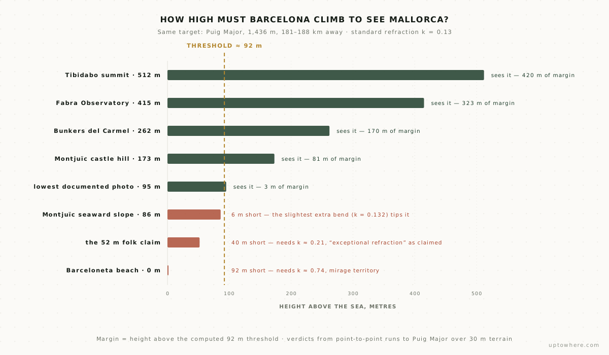
The city's own favourite miradors sort themselves neatly around these numbers, and the loss between them is steep. From the Bunkers del Carmel, at 262 m the city's best-loved sunset terrace, Puig Major stands 359 m above the horizon ray and Massanella 247 m, but the rest of the range has gone.
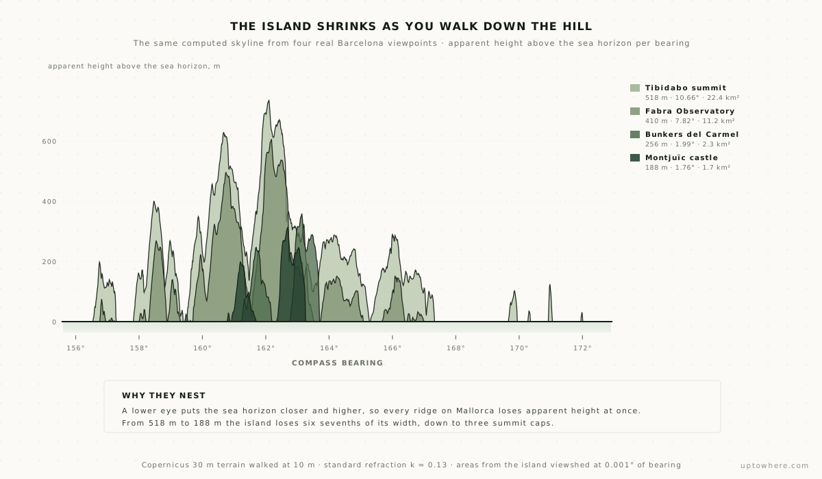
Between Tibidabo and Montjuïc there are 330 metres of altitude and about twenty minutes on a bus, and they are the difference between a fifteen-degree mountain range and three caps of rock. This is the single strongest lever anyone in Barcelona has: not the weather, not the season, not the lens. Height.
What bent air is actually worth
Refraction gets invoked whenever one of these photographs appears, usually as a hand-wave. It is measurable. We ran the entire dense sweep again at fourteen different values of the refraction coefficient, from dry unfavourable air to full ducting:
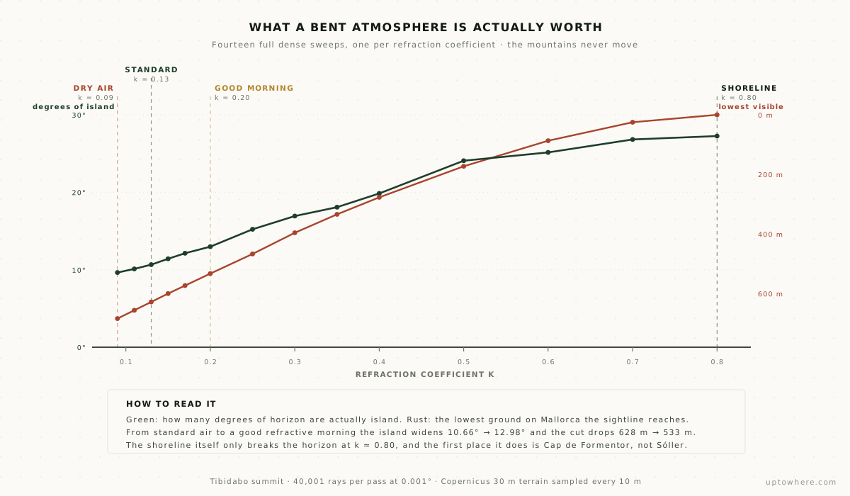
Going from standard air to a good refractive morning, k = 0.13 to 0.20, widens the island from 10.66° to 12.98° of horizon and drops the cut from 628 m to 533 m. It is worth roughly what 108 m of extra observer height is worth: Fabra at k = 0.20 sees about what Tibidabo sees in ordinary air. On the Barceloneta seafront the same shift takes the threshold from 93.85 m down to 59.82 m.
What refraction does not do, at any value we can defend, is show you the coast.
The "impossible" 2023 photo, split into its two parts
The Fabra Observatory photograph that "defies science" contains two different sightings, and they deserve separate verdicts.
The first is the mountain silhouette. From Fabra at 415 m, Puig Major stands 606 m above the sea-horizon ray and Massanella 498 m, under standard refraction. No anomaly, no mirage, no defiance of anything. A meteorologist photographing Mallorca's summits from that terrace on a clear November dawn is photographing ordinary, permanent geometry that most of the city happens not to know about.
The second half is the part nobody remarked on, and it is stranger than the mountains. The photo shows lights at Port de Sóller, a harbour at sea level. A sea-level target at 186 km is a completely different problem from a 1,436 m summit, and the obvious answer is that it took extraordinary refraction. It took something else: the water surface of that harbour cannot be seen from Barcelona at any refraction at all. Sóller's bay is closed by its own headland. Bend the air until the sea horizon is 160 km away and the blocker is no longer the curve of the Earth but a 27 m rock 270 m short of the target. Push the coefficient higher and the rock is still there.
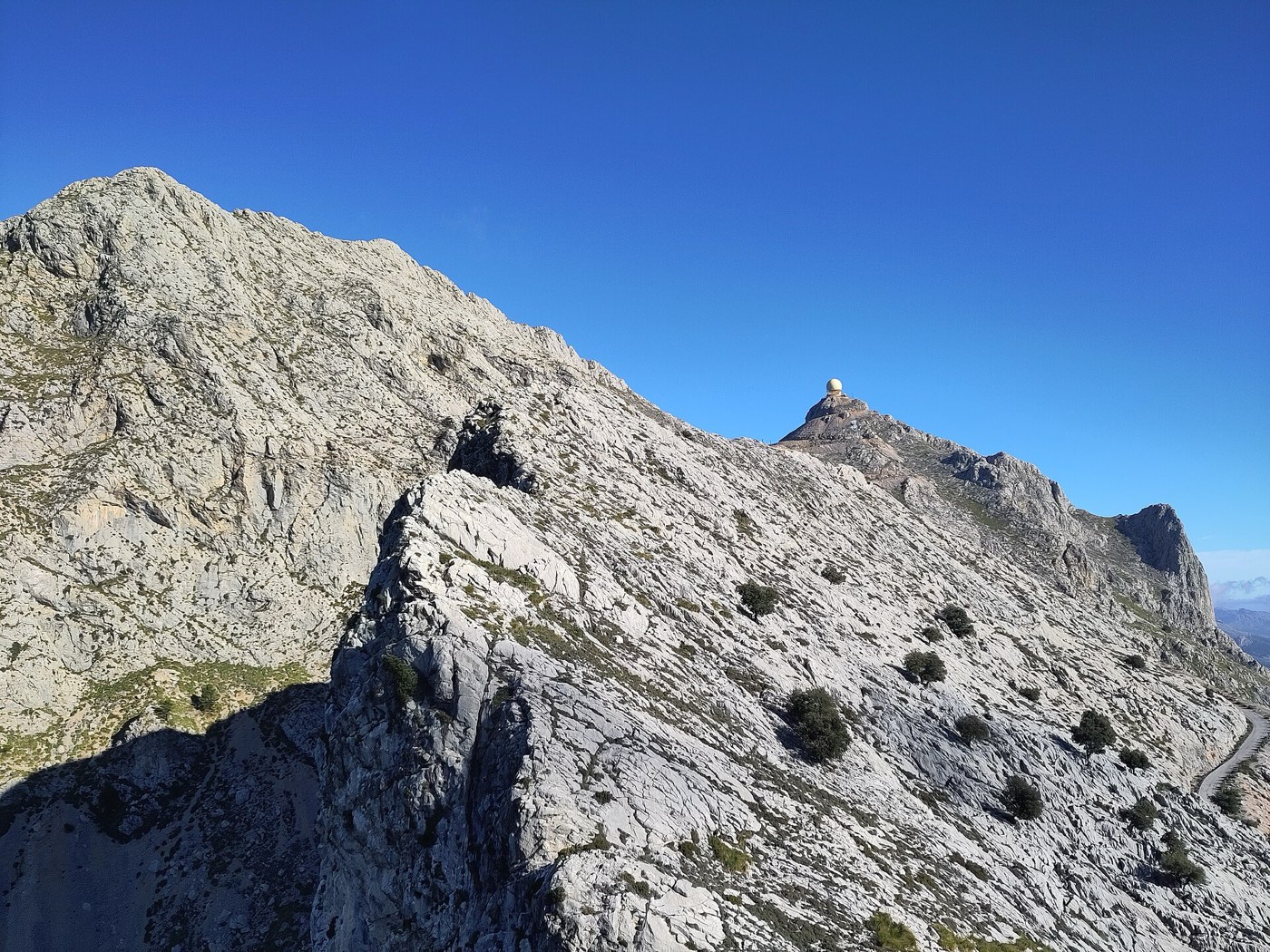
Photo: Joan Gené, CC0, via Wikimedia Commons.

So what is lit in that photograph is not the harbour surface. It is everything above about 27 m: the town on its slopes, the road, the houses climbing away from the water. And the first piece of Mallorcan shoreline that can ever reach Barcelona, at k ≈ 0.80, is not Sóller at all. It is Cap de Formentor, the island's far north-eastern tip, 186.7 km out on bearing 149.9°.
"Defies science" was exactly wrong, twice over. The part presented as impossible is routine. The part nobody remarked on is rarer than anyone claimed, and it is a different phenomenon entirely.
Mallorca is the farthest thing Barcelona can see
We also swept the city's whole horizon, all 360°, 144,000 rays out to 300 km, to see where the island sits in the full picture.
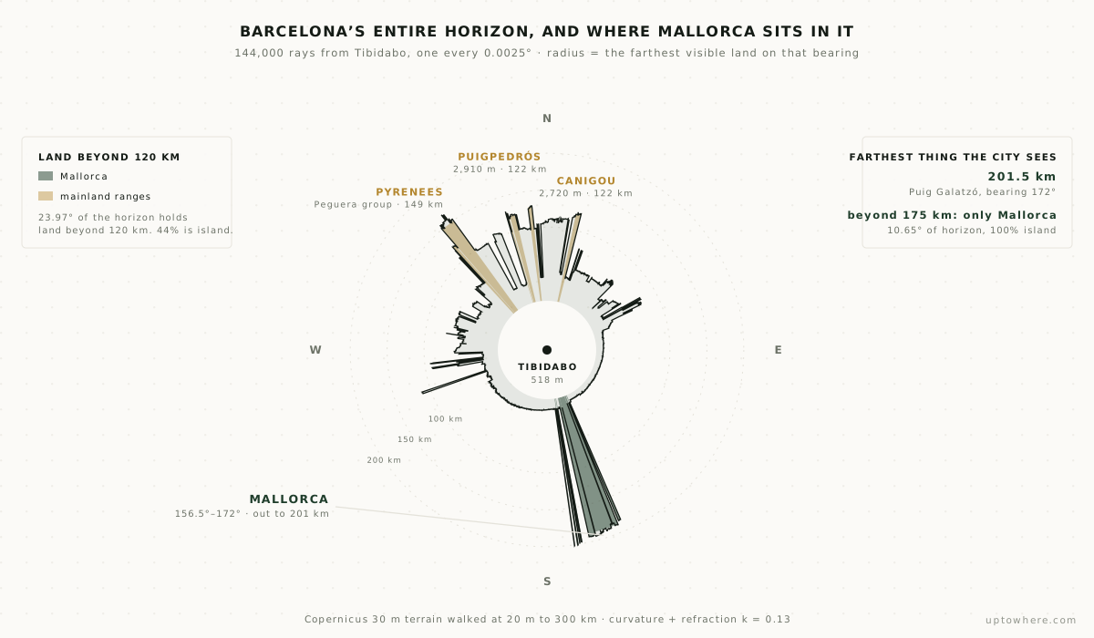
Barcelona has land on every one of the 144,000 bearings, because the city sits in a bowl of hills. But only 23.97° of its horizon holds land beyond 120 km, and 44% of that is Mallorca. Beyond 175 km the proportion is 100%: 10.65° of horizon, all of it island, and nothing else on Earth in view.
The farthest visible land in any direction is Puig Galatzó at 201.5 km, on bearing 172°. That beats every Pyrenean summit the city can see, including Canigou at 121.6 km and the Peguera group at 149.4 km. And the widest single block of distant land anywhere on the horizon is the Puig Major wall at 5.78°, wider than any mountain group on the mainland.
Barcelona thinks of the Pyrenees as its great distant view. The great distant view is out to sea.
Can Mallorca see Barcelona back?
Strictly yes, and it has to, because a sightline is reversible. The engine agrees with itself to within a third of a metre over 182 km: Barcelona needs 93.85 m of eye height to see Puig Major, and a Barcelona building needs 93.5 m to be seen from Puig Major. Same ray, read from both ends.
What is not symmetric is the scenery. Read from the summit, that shared ray says "everything in Barcelona below 93.5 m does not exist", which erases nearly the whole city: the beaches, the port, the Eixample. Only the thin crown of hills survives. From Puig Major, Tibidabo's summit clears by about 14 m, and Montjuïc castle by 9 m.
But Barcelona is not what Puig Major looks at. From that summit, 98.2° of the horizon holds land beyond 120 km, four times what Tibidabo gets. One unbroken 50.2° block is the Catalan mainland at 220.7 km, topped by Turó de l'Home on the Montseny. Another 26.3° is the Ebro country at 236 km. It sees Menorca, Ibiza, Formentera. And its farthest sightline runs 333.0 km to Montsent de Pallars, 2,883 m, deep in the Catalan Pyrenees, on bearing 334°, a line that passes clean over Barcelona's head.
So the island does not see very much of Barcelona. It sees an enormous amount of Catalonia. Given the records we've analysed, that 333 km Pyrenean line is a respectable entry in any long-sightline collection.
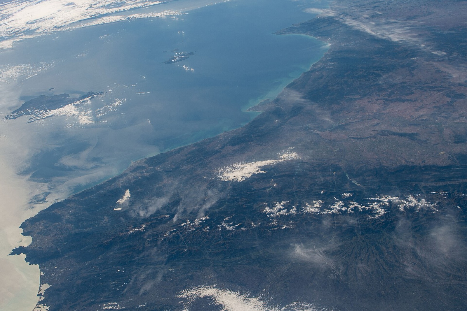
Photo: NASA, ISS061-E-13409, public domain, via Wikimedia Commons.

When to actually look
Geometry sets the stage permanently; aerosols decide the performance. Over 190 km of Mediterranean air, ordinary summer haze extinguishes the contrast long before the geometry fails, which is why both of the era-defining photographs of this sightline, Bret's in 2014 and Puertas's in 2023, were taken in mid-November. Cold, dry air behind a front, a low dawn sun backlighting the ridge silhouette, and a warm sea feeding a touch of extra refraction near the surface: that is the recipe, and it comes together a handful of mornings each autumn and winter.
From the geometry side the checklist is short. Get above 94 m. Face between 156.5° and 172°, and if you are near the threshold, 163.55° exactly. Prefer mornings. Every metre above the threshold adds margin against the day's air, and every metre of height is worth more than the weather is.
How the numbers were made
Every verdict above is a terrain profile walked sample by sample, at a uniform 10 m step from the observer to 245 km, with no coarsening at range. That density is not decoration: at a 100 m step, the kind long-range viewshed tools normally use, the same ray can walk straight over the ridge that decides the answer, and verdicts move by tens of metres. Positions come from WGS84 geodesics rather than a spherical approximation, which matters more than it sounds: at 188 km, the same bearing on a sphere lands 280 m away from where it lands on the ellipsoid, enough to read the wrong part of a ridge. Elevations are interpolated from the Copernicus GLO-30 model rather than snapped to the nearest cell. Earth's curvature and refraction enter as an effective radius R/(1−k), the surveying standard, evaluated with the local radius of curvature in each ray's own azimuth.
For the thresholds we bisected, to the centimetre for heights and to four decimal places for refraction coefficients, at every bearing. For the island viewshed we used the fact that at 0.001° angular spacing the rays are 3.3 m apart on arrival, finer than the 30 m terrain grid, so the union of visible sample points is a complete map rather than an interpolation.
Elevations come from a surface model with real summit values: its Puig Major cell reads 1,433 m against the surveyed 1,436 m, ordinary for a 30 m grid on a sharp peak. Every input is public and the whole pipeline is in our repository, so the study is reproducible.
Check your own horizon
Every disputed "you can see it from here" claim is a computation instead of an argument. If your coastline has its own version, an island that appears on certain mornings, a mountain someone's uncle swears he saw once, it is checkable:
- Run a 360° viewshed from your spot and see everything the terrain lets you see, in every direction.
- Use point-to-point mode to test a specific claim, with curvature, refraction and the exact blocking terrain named.
- Or browse 162 famous viewpoints we've already computed, Tibidabo, Montjuïc and the Bunkers del Carmel among them.
Test a sightline you've argued about, free
Frequently asked questions
Can you really see Mallorca from Barcelona?
Yes. Under standard atmospheric refraction, at least eleven named summits of the Serra de Tramuntana stand above the sea horizon as seen from Tibidabo's 512 m summit, led by Puig Major at 736 apparent metres above the horizon ray, 188 km away. No unusual weather is required. What limits sightings in practice is haze, which is why the documented photographs cluster on cold, clear autumn and winter mornings.
How high do you have to be in Barcelona to see Mallorca?
93.85 metres above the sea, under standard refraction, bisected to the centimetre at the seafront. And it has to be the right bearing: the minimum sits in a slot about a tenth of a degree wide centred on 163.55°, pointed at Puig Major's summit. A twentieth of a degree off and you need about 104 m. The lowest documented sighting, from 95 m on Montjuïc, clears the threshold by 1.2 m. From 52 m the island appears only with strong refraction (k = 0.218), and from the beach it would take k ≈ 0.37, which is a duct rather than ordinary bent air.
How much of Mallorca can you actually see from Barcelona?
22.4 km² out of 3,596, or 0.62% of the island, all of it crest of the Serra de Tramuntana. Palma, the beaches and the whole southern half are permanently below the horizon. Even among the land high enough to qualify, only about 14% is visible; the rest stands behind a nearer ridge.
Why does Mallorca look like separate floating fragments instead of an island?
Because Earth's curvature hides everything below about 630 to 900 m, depending on the bearing, and what protrudes is a serrated band. From Tibidabo the island arrives as eight separate pieces spread across 15.46° of horizon, of which only 10.66° is island and the rest is open sea showing through the gaps. The largest single piece is a 5.78° wall running from Massanella across Puig Major.
Was the 2023 photo of Mallorca from the Fabra Observatory real?
Yes, and it contains two different phenomena. The mountain silhouette was ordinary geometry: from Fabra's 415 m, Puig Major stands 606 m above the sea-horizon ray under standard refraction. The lights near Port de Sóller are the rare part, and rarer than we first said: the harbour's water surface is blocked by the bay's own headland at any refraction coefficient, so what was lit must be the town on the slopes above it, from roughly 27 m upward. The summits did not defy science, and the harbour lights defied the geography, not the physics.
Can you see Barcelona from Mallorca?
Yes, and rather more of Catalonia than of Barcelona. From the summit of Puig Major, Tibidabo's summit clears by about 14 m and Montjuïc castle by 9 m, but almost all of the city lies below the 93.5 m that the shared ray demands. What the summit does see is 98.2° of horizon holding land beyond 120 km, including 50.2° of unbroken Catalan mainland at 220 km and a 333 km sightline to Montsent de Pallars in the Pyrenees.
What is the farthest thing you can see from Barcelona?
Mallorca. Puig Galatzó, at 201.5 km on bearing 172°, is the farthest visible land in any direction from Tibidabo, beating every Pyrenean summit the city can see. Beyond 175 km, Mallorca is the only land on Barcelona's horizon at all.
How was this computed?
By walking every sightline at a uniform 10 m step over the 30 m Copernicus GLO-30 elevation model, with Earth's curvature and atmospheric refraction in the geometry, on WGS84 geodesics with interpolated elevations. The island window was swept at 0.001° of bearing, 40,001 rays per pass, once for each of fourteen refraction coefficients and each of six Barcelona viewpoints. Thresholds were found by bisection at every bearing, and the whole 360° horizon was swept separately at 144,000 rays. UpToWhere runs the same class of computation for any pair of points on Earth.