 UpToWhere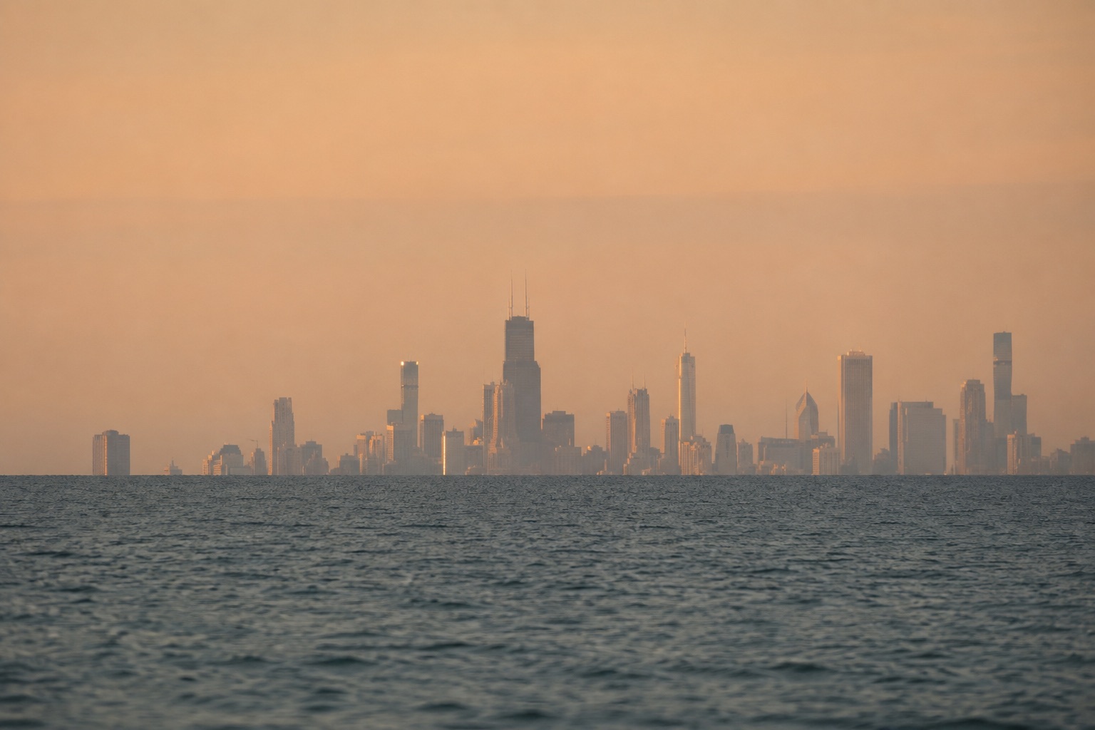
Stand on a beach and watch a ship sail out: first the hull vanishes, then the deck, and for a while the superstructure glides along the horizon like a cutout. Nothing is wrong with your eyes. You are watching the planet curve.
The amount of curvature is famously small: about 7.8 centimetres (3.1 in) over one kilometre. The catch is that it doesn't grow linearly. It grows with the square of distance, and that square is what swallows skylines.
The drop, and why it isn't the number you want
The often-quoted figure ("8 inches per mile, squared") measures how far the surface drops below a perfectly straight tangent line:
drop ≈ d² / (2 × R) ≈ 7.85 cm × (d in km)²
At 1 km (0.6 mi) that's 8 cm (3.1 in). At 10 km (6.2 mi), 7.8 m (26 ft). At 100 km (62 mi), 785 m (2,576 ft), the height of a mountain.
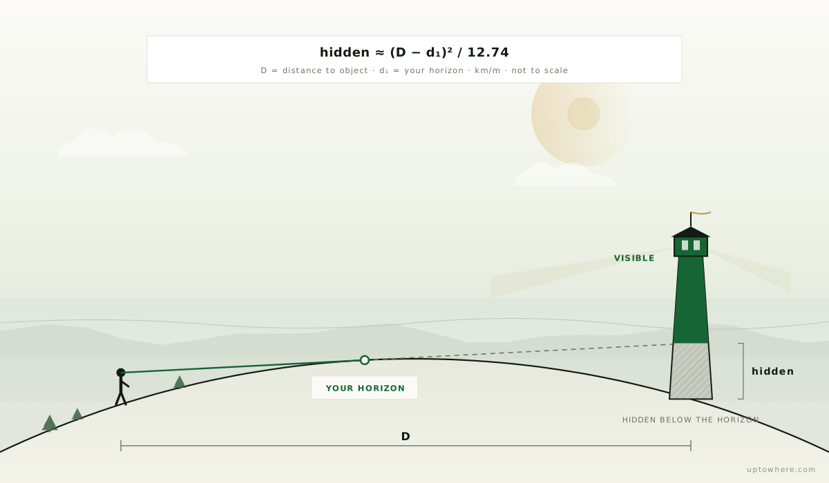
But the drop alone answers the wrong question, because you are not lying on the ground. Your eyes are somewhere above the surface, and that height pushes your horizon outward before any hiding begins:
horizon distance ≈ 3.57 × √h [km, h in metres]
Only beyond that line does the planet start stealing height from distant objects:
hidden height ≈ ( (d − 3.57 × √h) / 3.57 )² [m]
What that means in practice
For a person standing at the shore (eyes at 1.7 m / 5.6 ft, horizon at ~4.7 km / 2.9 mi):
| Distance to object | Hidden below horizon |
|---|---|
| 5 km (3.1 mi) | ~0 m: hull just starting to dip |
| 10 km (6.2 mi) | ~2 m (6.6 ft): small boats gone |
| 20 km (12 mi) | ~18 m (59 ft): a five-storey building gone |
| 50 km (31 mi) | ~160 m (525 ft): most skyscrapers gone |
| 90 km (56 mi) | ~570 m (1,870 ft): entire skylines gone |
That last row is the famous one. Chicago's skyline photographed from the Michigan shore, roughly 90 km (56 mi) across the lake, shows towers missing their bottom 500+ metres (1,640+ ft): only the upper floors of the tallest buildings float above the water. The photos are real; the missing floors are the curvature doing exactly what the formula says.
You can watch the same theft happen step by step. Malmö's Turning Torso, a 190 m (623 ft) tower standing right on the Öresund shore, has been photographed from points all along the Danish coast opposite, and lining the shots up makes the formula visible: from up close the tower stands on the ground; from Amager Beach in Copenhagen, 22 km (14 mi) out, its lowest floors are already under the water line; from Vedbæk, 36 km (22 mi) out, more than a third of the building is gone and the city around it has vanished entirely.
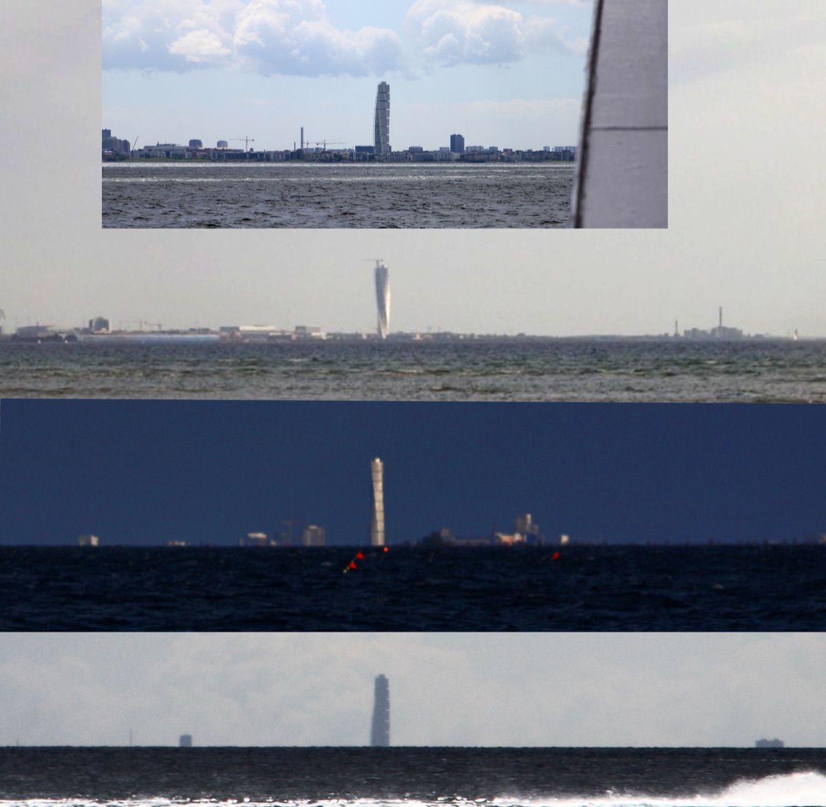
Photos: Eduard47, Väsk, Guillaume Baviere, CC BY-SA 4.0, via Wikimedia Commons.

Two refinements worth knowing:
- Refraction gives some height back. Air density falling with altitude bends light gently around the curve, reducing the hidden height by roughly 15 % in standard conditions, and far more during temperature inversions, when distant shores can loom into view. Details in How Far Can You Actually See?
- Height works from both ends. A target hidden from the beach may be visible from the dunes. Climb 10 m (33 ft) and your horizon jumps from 4.7 km to 11 km (2.9 to 6.8 mi), and every hidden height beyond it shrinks.
When refraction goes to extremes, it stops being a correction and becomes the whole picture. On a warm spring day over the still-cold Gulf of Riga, light bending through the temperature inversion did this to three perfectly ordinary cargo ships:
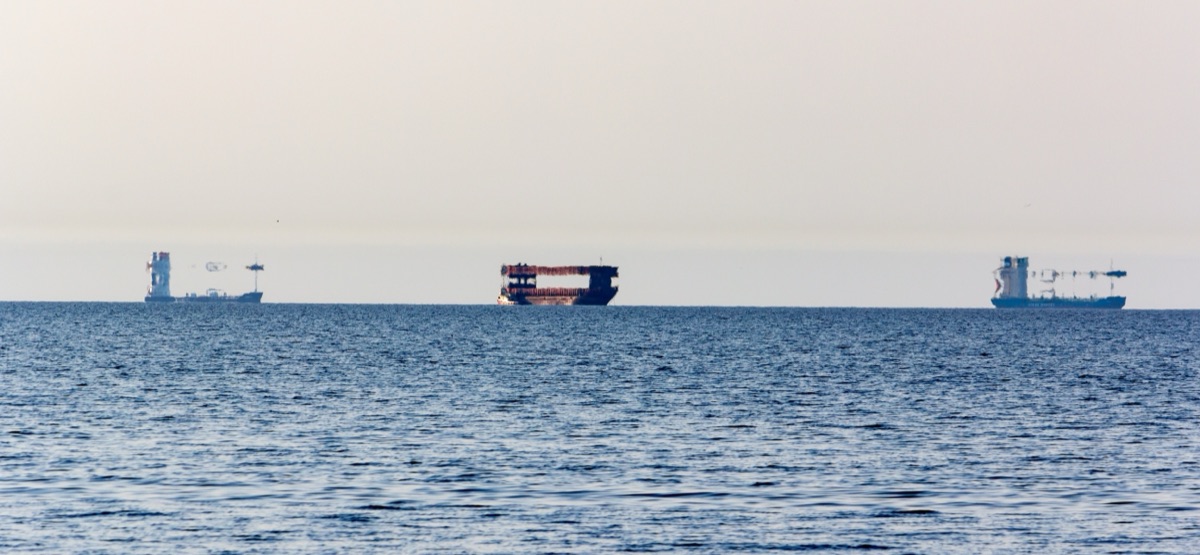
Photo: Juris Seņņikovs, CC BY-SA 4.0, via Wikimedia Commons.

Mountains: the objects that win anyway
The same math explains the opposite phenomenon: seeing absurdly far. A 3,000 m (9,843 ft) peak only becomes fully hidden from sea level at about 200 km (124 mi); from another summit, considerably farther. Stack two mountains and dry air, and you get the 400+ km (249+ mi) record sightlines: the Pyrenees photographed from the Alps, one country seen from another.
This is also why "how far can I see?" has no single answer: it depends on your height, the target's height, and every ridge in between. Which is a terrain computation, not a formula.
Skip the formula, compute the real thing
UpToWhere runs the full calculation (curvature, standard refraction, and 30 m-resolution terrain) in every direction at once:
- The 360° visibility analysis shows exactly which land is visible from any point, and what the curve hides.
- Every result names the farthest visible point, your personal answer to "how far can I see from here?"
- For a sanity check, browse 162 famous viewpoints with the analysis pre-computed, from Mont Blanc to the Willis Tower, whose deck looks across Lake Michigan at the same geometry that hides Chicago from the far shore.
Want the numbers for your own height first? The earth curvature calculator gives the distance to your horizon, the hidden height of anything beyond it, and the drop per mile and per kilometre.
See what the curvature hides from your spot
Frequently asked questions
How much does the Earth curve per kilometre?
The surface drops about 7.8 centimetres (3.1 in) below a straight tangent line over the first kilometre. The drop grows with the square of distance: roughly 7.8 m (26 ft) at 10 km (6.2 mi) and 785 m (2,576 ft) at 100 km (62 mi).
Why can I see a city 90 km (56 mi) away if the drop at 90 km is 600+ metres (1,969+ ft)?
Because the drop is measured from a tangent line at the surface, and neither you nor the city are at zero height. Your eye height moves the horizon outward, the buildings' height lifts them above it, and refraction bends light around the curve slightly. What disappears is only the portion of the target below the hidden-height value for your geometry.
Does atmospheric refraction cancel Earth's curvature?
No: under standard conditions it offsets roughly one seventh of it, extending horizons by 7–8 %. Strong temperature inversions can bend light much further and temporarily reveal objects that are geometrically well below the horizon (superior mirages), which is how several record-distance observations were made.
How do I calculate how much of a distant mountain is hidden?
Subtract your horizon distance (3.57 × √h, with h your eye height in metres) from the distance to the mountain, divide by 3.57, and square the result: that's the hidden metres in a smooth-Earth model. For the real answer with terrain in between, run a free viewshed analysis from your exact spot.