 UpToWhere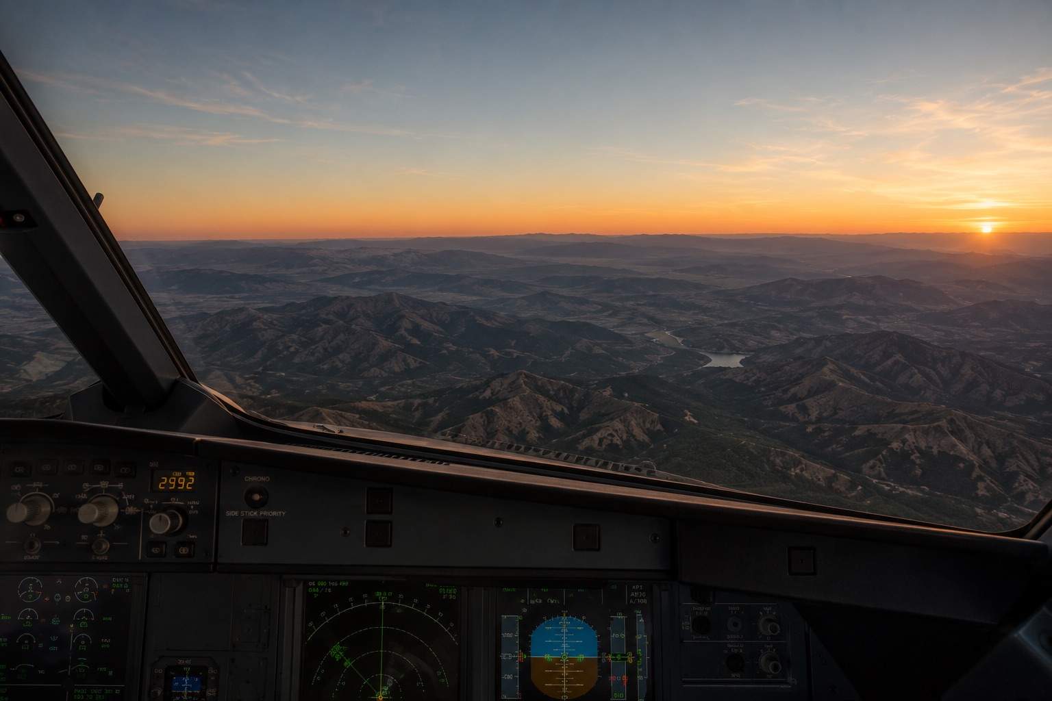
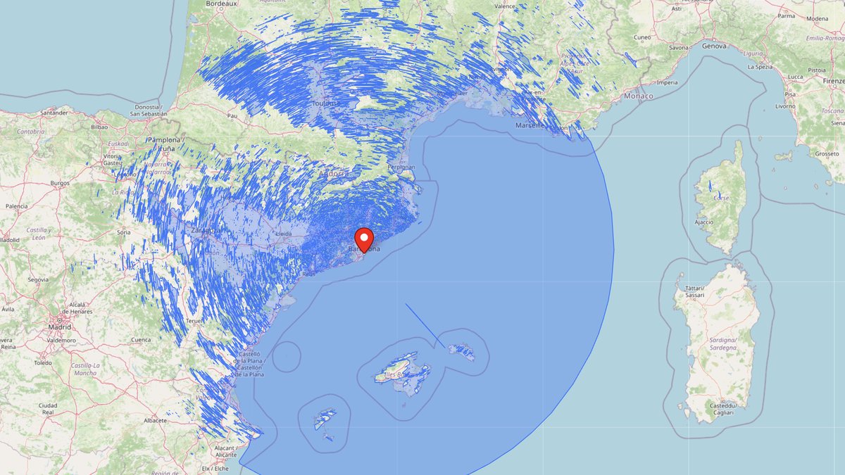
Take a window seat on any flight and, somewhere over the climb, a strange thing happens: the horizon stops being a line in the landscape and becomes a property of the planet. From a cruising airliner at 11,000 m (36,000 ft), the geometric horizon lies about 375 km (233 mi) away, farther than Madrid to Valencia. And when we ran the actual terrain computation from 11,000 m above Barcelona, one glance covered 668,689 km² (258,222 mi²) of Earth (more than metropolitan France), with the farthest visible point a mountain in Corsica, 580 km (360 mi) away.
Those numbers come from the same horizon formula that governs a beach stroll, just fed a much bigger height. And because a viewshed calculator doesn't care whether the "observer" is a person, a mast or a wing seat, you can compute the exact view from any altitude: which terrain is visible, which is hidden, and which side of the plane to sit on.
The altitude ladder
Horizon distance grows with the square root of height: d ≈ 3.57 × √h km (add ~8 % for atmospheric refraction). Climb the ladder and watch the planet unfold:
| Height | You are… | Geometric horizon | Area in view |
|---|---|---|---|
| 1.8 m (5.9 ft) | standing on the beach | ~4.8 km (~3.0 mi) | ~72 km² (~28 mi²) |
| 30 m (98 ft) | on a radio mast | ~20 km (~12 mi) | ~1,200 km² (~463 mi²) |
| 120 m (394 ft) | at the legal drone ceiling | ~39 km (~24 mi) | ~4,800 km² (~1,853 mi²) |
| 1,000 m (3,281 ft) | in a hot-air balloon | ~113 km (~70 mi) | ~40,000 km² (~15,444 mi²) |
| 4,000 m (13,123 ft) | at skydive exit altitude | ~226 km (~140 mi) | ~160,000 km² (~61,776 mi²) |
| 11,000 m (36,000 ft) | in a cruising airliner | ~375 km (~233 mi) | ~440,000 km² (~169,925 mi²) |
| 20,000 m (65,600 ft) | in a stratospheric balloon | ~505 km (~314 mi) | ~800,000 km² (~308,882 mi²) |
| 39,000 m (128,000 ft) | at Felix Baumgartner's jump | ~705 km (~438 mi) | ~1,560,000 km² (~602,319 mi²) |
| 400 km (249 mi) | on the ISS | ~2,300 km (~1,429 mi) | ~16,500,000 km² (~6,370,683 mi²) |
These are smooth-Earth minimums. Real runs come out bigger: refraction adds ~8 % of reach, and any terrain that pokes above the horizon adds area beyond it, which is how our measured 11,000 m result beat the table by 50 %.
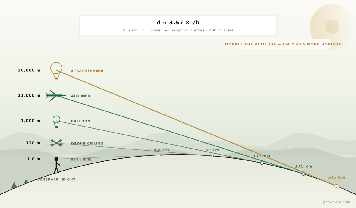
The last rung of that ladder isn't a formula anymore: it's a photograph. From the ISS, the same geometry that gives an airliner its 375 km horizon stretches out to roughly 2,300 km, and the curve stops being subtle:
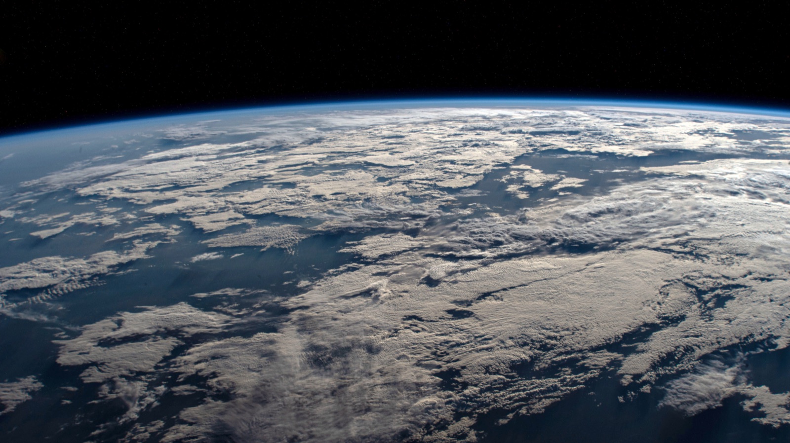
Photo: NASA, public domain (source).

The square-root tax, and the linear reward
The square root is a harsh tax on distance: doubling your altitude buys only 41 % more horizon. An airliner flies 90× higher than a hot-air balloon but sees barely 3.3× farther. The last 1,000 m (3,281 ft) of climb to cruise altitude adds just ~17 km (11 mi) of horizon; the first 1,000 m added 113 km (70 mi).
Visible area is the consolation prize. Since area grows with the square of distance and distance with the square root of height, area grows linearly: on a smooth Earth, every metre of altitude buys almost exactly 40 km² of planet (~15 mi²; π × 3.57² ≈ 40). Take an elevator one floor up and you've annexed a small city's worth of view. It's the same reason the difference between a 200 m (656 ft) and 300 m (984 ft) observation deck is easy to feel but hard to see.
When does terrain stop mattering?
Here's the question the formula can't answer, and a terrain-aware viewshed can. At eye level, geometry is almost irrelevant: the ridge behind your house decides everything, and a valley location might see 3 km in one direction and 300 m in another. Raise the observer and the viewshed blooms: at drone height the local ridge still bites, at 1,000 m most nearby terrain has sunk below your sightlines, and the shattered starburst of a ground-level viewshed rounds out toward a disc.
But it never becomes a perfect disc. Even from 11,000 m (36,000 ft), a 3,000 m (9,843 ft) mountain range 200 km (124 mi) away still hides the valleys behind it: your sightline grazes the crest at a shallow angle and everything in its terrain shadow stays hidden. From a plane you see the ranges of a continent, laid out like a relief map, while the terrain tucked behind each one remains invisible. The view from altitude isn't "everything"; it's a precise geometry problem, the same one behind the longest sightlines on Earth.
And geometry allows some spectacular pairings: an airliner at cruise (horizon 375 km / 233 mi) and the summit of Everest (horizon 335 km / 208 mi) could theoretically exchange a sightline over 700 km (435 mi). Air clarity says no long before geometry does, but it's why Everest is routinely spotted from flights crossing the Ganges plain 300 km (186 mi) away, and why Mont Blanc marks flights across half of France.
Our Barcelona run produced one of these: the farthest visible point was Monte d'Oro (2,389 m / 7,838 ft) in Corsica, 580 km (360 mi) away. Check the geometry and it gets better: the purely geometric limit for that pairing is 3.57 × (√11,025 + √2,389) ≈ 549 km (341 mi), short of the actual 580 km (360 mi) distance. With standard refraction the constant becomes 3.86 and the limit stretches to ≈ 594 km (369 mi). That sightline exists only because the atmosphere bends light around the curve: erase refraction and Corsica drops below the horizon.
The same atmosphere that bends every sightline in this article is, from orbit, almost nothing at all, a blue thread against the black:
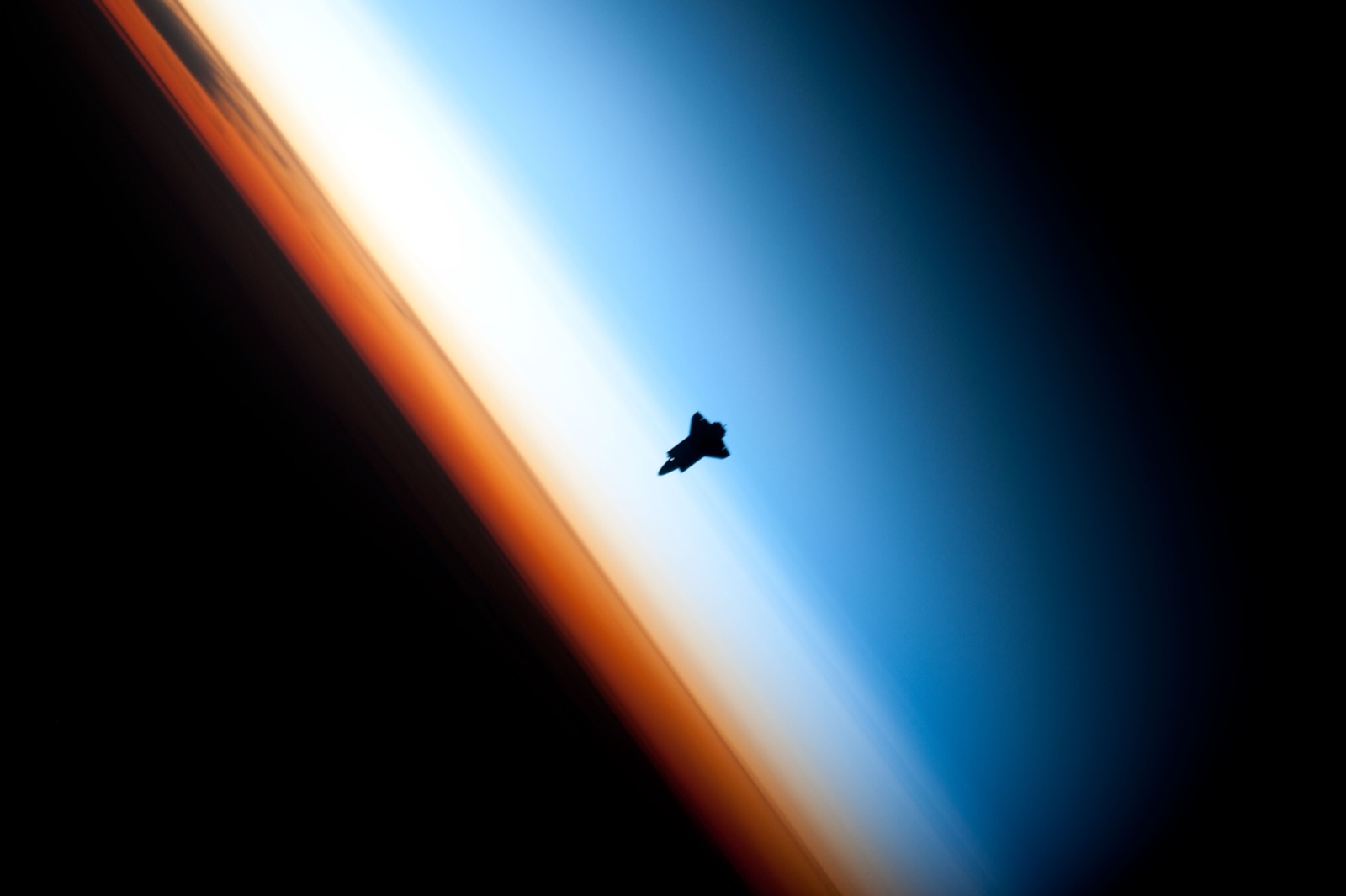
Photo: NASA/Crew of Expedition 22, public domain (source).

Pick your window seat with a viewshed
This is the quietly useful part. UpToWhere's observer height isn't limited to eye level: it's a free-typed number. Set it to your cruise altitude at a point along your route and you get the actual view from that seat. That's exactly how the Barcelona result above was made: a pin on the coast, 11,000 m (36,000 ft) in the height field, and a 360° analysis. The map that comes back is a physics lesson in one picture: a clean disc out to the ~405 km (252 mi) sea horizon over the Mediterranean, shattered blue streaks across Spain and France where the Pyrenees carve shadow wedges, and Corsica's ridges just catching the sightline at the far edge.
- Drop a pin on a waypoint of your flight path, set the height to your cruise altitude, and run the analysis.
- The viewshed shows which ranges are visible in which direction, so you know whether the Alps show up on the left or the right of the aisle.
- The same trick works at 1,000 m (3,281 ft) for a balloon flight, at glider or paragliding altitudes, or at 120 m (394 ft) to plan a drone flight.
The calculator checks terrain out to 1,000 km (beyond any sightline the atmosphere will ever grant) using 30 m Copernicus elevation data with curvature and refraction included.
Compute the view from any altitude
Frequently asked questions
How far can you see from a plane window?
From a typical cruising altitude of 11,000 m (36,000 ft), the geometric horizon is about 375 km (233 mi) away, roughly 405 km (252 mi) with standard atmospheric refraction. Elevated terrain remains visible beyond that: our computed run from 11,000 m above Barcelona reached Monte d'Oro in Corsica at 580 km (360 mi). In practice, haze usually limits recognizable ground detail to much less, but large mountains and city lights at 250–300 km (155–186 mi) are regularly visible in clean air.
Can you see Earth's curvature from a plane?
Barely. At airliner altitude the horizon drops only about 3° below level and its curvature is subtle: you need a wide, unobstructed view and a sharp horizon to perceive it. It becomes unambiguous from around 18–20 km (11–12 mi), which is why stratospheric balloon photos show an obviously curved horizon while window-seat photos don't.
How far can you see from a hot-air balloon?
Typical sightseeing balloons fly 300–1,000 m (984–3,281 ft) above ground. At 1,000 m (3,281 ft) the geometric horizon is about 113 km (70 mi) away, already enough to see a whole region at once. What you actually see depends on the terrain: nearby hills can still block whole sectors, which is exactly what a viewshed calculation reveals.
Does being higher always mean seeing farther?
Distance-wise yes, but with sharply diminishing returns: horizon distance grows with the square root of height, so doubling your altitude only adds 41 % more range. Visible area, however, grows linearly with height: every extra metre of altitude adds roughly 40 km² (15 mi²) of Earth to your view on smooth terrain.