 UpToWhere
On August 12, 2026, totality crosses northern Spain between 20:27 and 20:33 CEST with the sun only a handful of degrees above the west-northwest horizon (bearing ≈ 285°). We covered why that makes your western horizon the critical variable. This piece is the practical sequel: which of Spain's famous high viewpoints actually work for it, based on their real, terrain-computed sightlines. If you want the verdict for an ordinary town rather than a summit, see who actually sees totality, or check any point yourself on the Eclipse Horizon Checker.
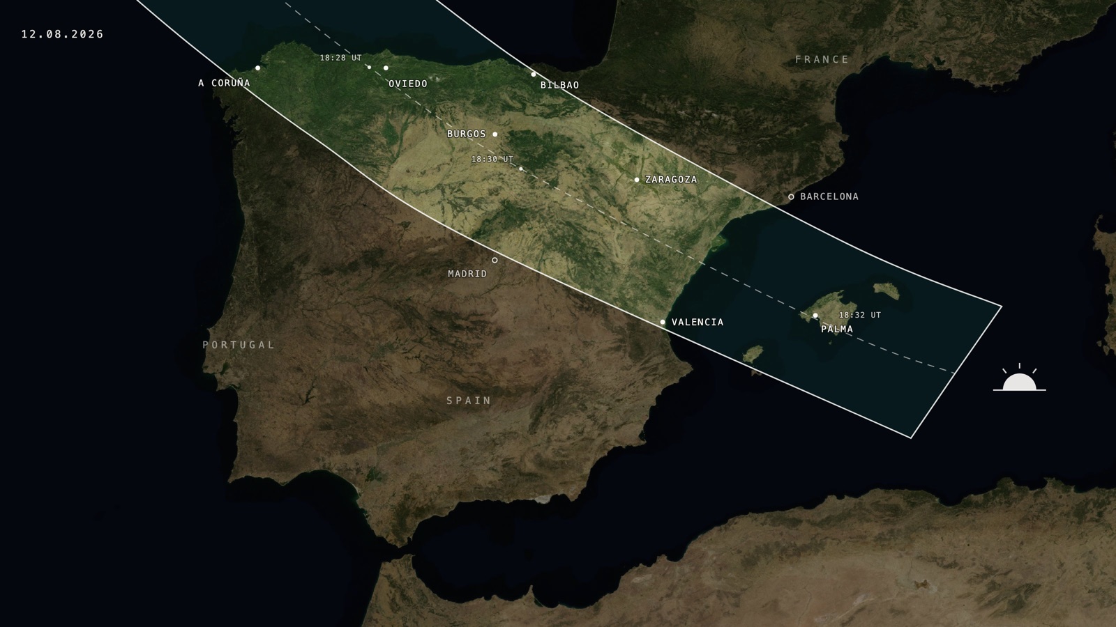
The rule for every candidate spot is the same: inside the band, with 10+ km (6+ mi) of open terrain toward 285°. Altitude helps enormously: every metre pushes your horizon down and buys seconds of visible sun, but only if the mountain itself doesn't put a taller neighbour precisely to your west.
Get it right and this is the prize. The last time a totality crossed high mountains with the sun low in the sky (Chile, July 2019), it looked like this from the summit of La Silla:
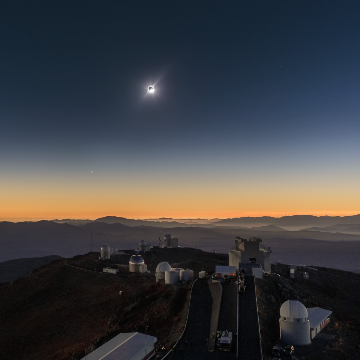
Photo: ESO/P. Aniol, M. Druckmüller, P. Horálek, CC BY 4.0, via Wikimedia Commons.
.jpg)
Inside the band: the strong picks
Torre de Cerredo: the Picos grandstand
The highest point of the Picos de Europa (2,650 m / 8,694 ft) sits squarely in the totality band, in the region with the longest durations of the Spanish path (~1 min 45 s around Asturias). Its terrain analysis shows sightlines reaching 278 km (173 mi), and from that elevation the WNW horizon drops far below the geometric ideal: the eclipsed sun will stand clearly above it. The honest caveats: reaching the summit is a serious scramble, and the Cantabrian coast's evening cloud is a real risk. The Fuente Dé cable car area nearby offers high, west-open alternatives without the climbing grade.
Moncayo: the Ebro valley's watchtower
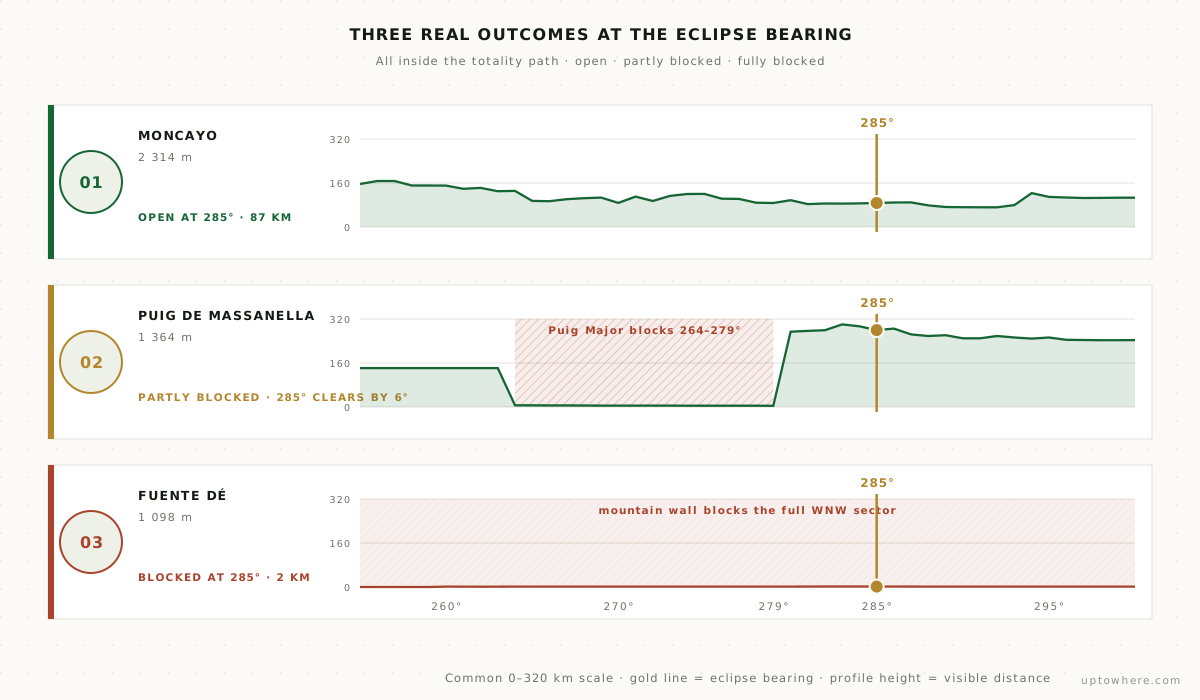
Moncayo (2,314 m / 7,592 ft) is possibly the most practical great summit of the eclipse: inside the band near Zaragoza, in the statistically clearest evening skies of the Spanish path (the Ebro depression), and standing alone: its analysis shows 280 km (174 mi) of maximum reach with no comparable peak anywhere near it. Toward 285° the terrain falls away into the plateau of Soria. A well-marked trail reaches the summit; even the Santuario parking area at ~1,600 m (5,249 ft) keeps a wide open west.
The high Pyrenees: with an asterisk
Aneto (3,404 m / 11,168 ft, sightlines to 320 km (199 mi)) and Monte Perdido (3,355 m / 11,007 ft) are the biggest sky platforms in the country, but they sit close to the northern limit of the band, where totality is short or absent. Check a detailed totality map before committing to either, and remember what 20:30 on a 3,000 m (9,843 ft) summit means: descending in the dark. For most people the Pyrenean foothills further south (inside the band, west-open, road-accessible) are the smarter trade.
The near-miss: Mallorca's highest trail summit
Puig de Massanella (1,364 m / 4,475 ft) looks like it should be the cautionary tale here: the higher Puig Major stands only 4.7 km (2.9 mi) away, almost due west, and blocks the horizon completely across a real, measured sector (bearings 264°–279°, distance collapsing to a few kilometres). But check the actual number: totality's sun sits at 285°, six degrees past where Puig Major's shoulder ends, and Massanella's own terrain analysis shows the view reopening hard right there, reaching past 280 km (174 mi) toward its 317 km (197 mi) maximum. It clears, barely. That's the value of a real per-degree analysis over a "the mountain's in the way" guess: on Mallorca the safer, zero-doubt picks are still the Tramuntana's west-facing coastal miradores or the shoreline itself, where the eclipsed sun hangs 1–3° over open sea, but the summit itself isn't the trap it first looks like.
Famous, beloved, and outside the band
- Peñalara and the Guadarrama summits: Madrid is outside totality. A deep partial, nothing more.
- Montserrat and Tibidabo: Barcelona misses it too: 99 % partial is not totality, and the difference is night and day. Literally.
- Teide: wrong archipelago entirely for this one.
If you're in Madrid or Barcelona, the trip north is worth it, and the existing crowd forecasts say everyone else thinks so too. Book with your horizon already verified.
Don't need a summit: need 285° open
The eclipse doesn't require a famous mountain. It requires being inside the band with the WNW clear: a west-facing slope, a reservoir shore, a village mirador above the Ebro. Every candidate spot can be verified in half a minute:
- Open the visibility calculator, drop the observer on your spot.
- Look at the result toward 285°: you want 10+ km (6+ mi) of open terrain, or sea.
- If a ridge closes it, move uphill or northwest and run it again.
Verify your eclipse spot's western horizon, free
Frequently asked questions
Do I need to climb a mountain to see the 2026 eclipse well?
No. Altitude buys margin, but any spot inside the totality band with 10+ km (6+ mi) of open terrain toward bearing 285° works. A low hill with a clear west beats a high summit with a taller neighbour to its WNW.
Which Spanish region has the best odds for the 2026 eclipse?
The Ebro valley around Zaragoza combines a wide, accessible stretch of the band with the best August evening cloud statistics of the path. The Cantabrian coast has longer totality but more evening cloud risk; the Balearics have the sun lowest, best watched from the water's edge.
Is Aneto inside the path of totality?
It sits near the band's northern limit, where totality is marginal at best: verify against a detailed eclipse map before planning around it, and consider the descent-in-darkness problem of any 3,000 m (9,843 ft) summit at 20:30. The foothills south of the high Pyrenees are safely inside the band.
Can I watch it from Madrid or Barcelona?
Both cities are outside totality and will see only a deep partial eclipse. Totality requires traveling into the band: for Madrid, roughly 1.5–2 hours north; for Barcelona, west or southwest toward the band.