 UpToWhere
Every Tenerife guidebook repeats the same line: at dawn and dusk, Mount Teide casts "the largest shadow in the world projected over the sea": a perfect blue triangle, forty kilometres long, reaching the island of La Gomera. Climbers on Everest tell a bigger story: a pyramid of shade two hundred kilometres across the Himalaya. Reddit falls in love with a photo of one or the other every single year.
Nobody, as far as we can tell, has ever actually measured them against each other.
So we did. Twelve of the world's great free-standing peaks. Every sunrise and every sunset of a full year, traced through 30 m elevation data with the same curved-ray geometry that powers our calculator. The answers surprised us repeatedly: the world's longest mountain shadow belongs to none of the famous claimants, the tallest mountain on Earth doesn't even reach the podium, and Teide (whose legend undersells it by an order of magnitude) turns out to hold a record no other mountain on the planet can match.
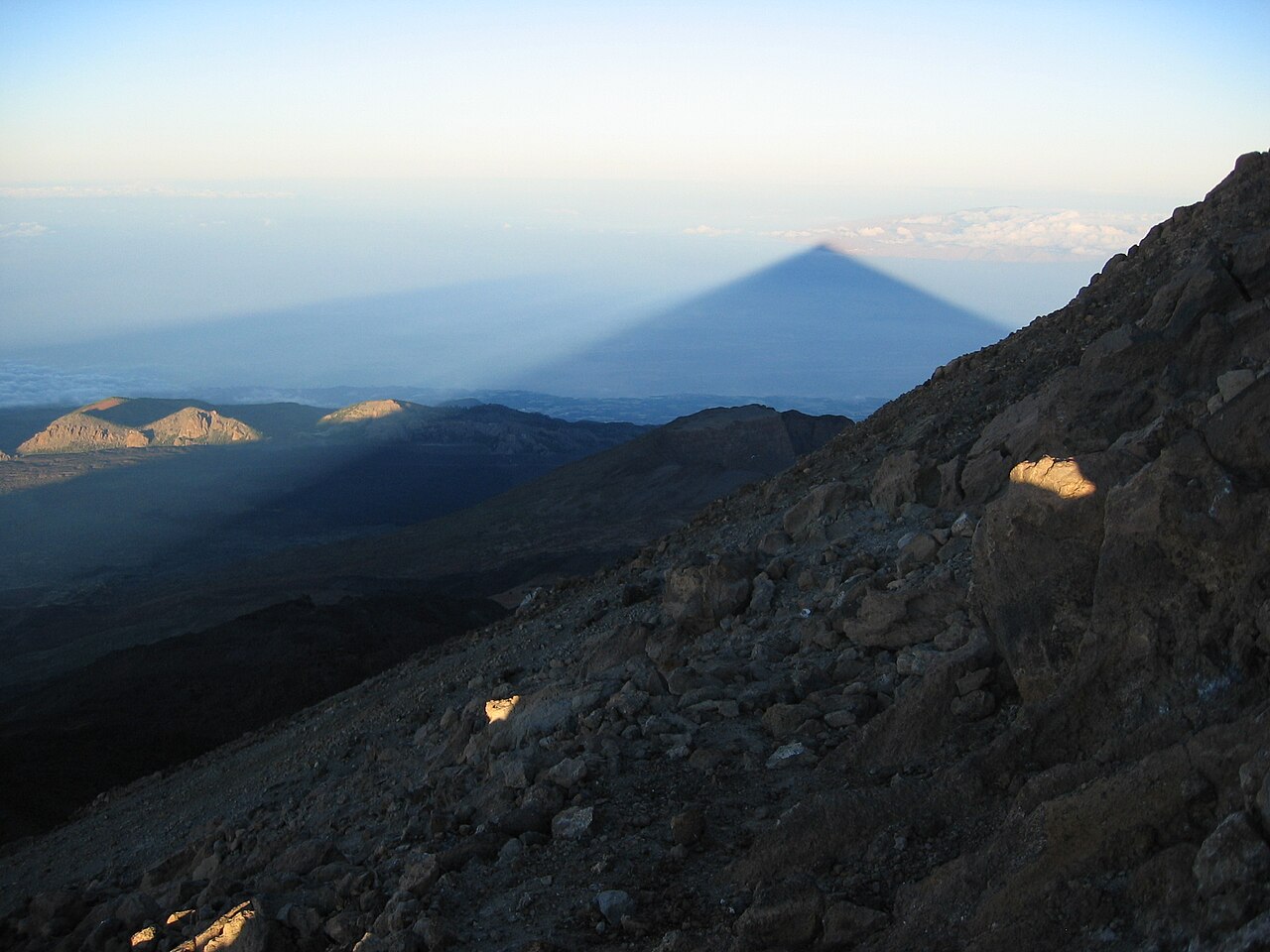
Photo: Dr.michi, CC BY-SA 3.0, via Wikimedia Commons.

A shadow is born at the horizon
Before any ranking makes sense, you have to decide what "how long is the shadow" even means, and the physics here is stranger than we expected when we started.
Take Teide on the March equinox. Our terrain model puts first light on the summit at 07:01:18 UTC, while the sun is still 1.7 degrees below horizontal: the summit's height lets it see over the curve of the ocean, so it catches the sun early. At that moment the mountain casts a shadow, but the shadow has no tip. It reaches out over the dark Atlantic and simply merges with the retreating night. Asking its length is meaningless: the whole western hemisphere of sky and sea is still in shade. Every mountain's shadow is infinite at first light.
Then, twenty minutes later, something remarkable happens. As the sun climbs past the summit's own horizon-dip angle, the grazing ray that skims the summit finally bends down far enough to touch the sea, and the shadow's tip is born, 215.8 km away, at the summit's own sea horizon. From there it races back toward the mountain as the sun rises: two minutes after touching down it has already retreated to ~120 km, an average speed of nearly 2,900 km/h. By 07:41 the shadow is a modest 36 km long. The giant triangle tourists photograph is the tail end of a collapse that began at the edge of the visible world.
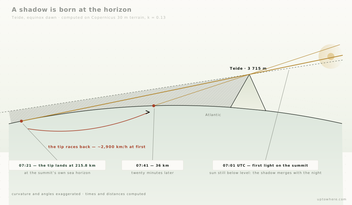
That gives us a clean, honest definition for the leaderboard: the farthest point where a mountain's summit shadow actually lands on the Earth's surface, at the moment it first touches down. Everything in this article uses it.
Why every mountain's shadow is a triangle
One more piece of physics, because it decides what the photos show. Teide's shadow is a crisp pyramid. So is Rainier's, Fuji's, Kilimanjaro's, and none of those summits is remotely pyramid-shaped from above. Tourist sites usually credit "aerial perspective." The real explanation is simpler and better.
Seen from above, a mountain's shadow at grazing sun is a prism: a band roughly as wide as the mountain, running nearly parallel for hundreds of kilometres. When you stand on the summit and look along it, you are looking down a tunnel of shade whose far end is unimaginably distant. Perspective does to that tunnel exactly what it does to railway tracks: any cross-section, whatever its shape, converges toward a single vanishing point at the antisolar spot on the horizon. The pointed apex isn't the end of the shadow. It's a vanishing point: the optical signature of a shadow too long to see the end of.
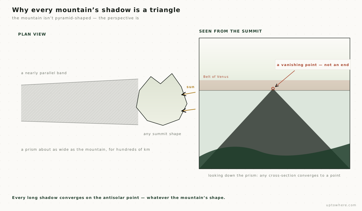
You can see the proof in the sky itself. At dawn the apex floats inside the pink band of the Belt of Venus (the Earth's own shadow rising in the west) precisely where the antisolar point sits. The mountain's shadow and the planet's shadow share a vanishing point:
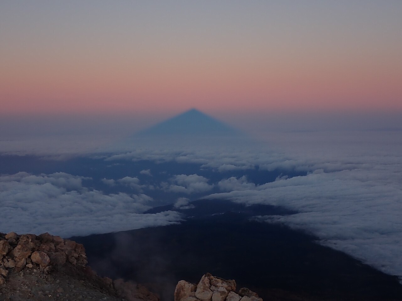
Photo: Cactus26, CC BY-SA 3.0, via Wikimedia Commons.

What we ran
Everything below comes from the engine behind UpToWhere, on 30 m Copernicus elevation data, with Earth's curvature and standard atmospheric refraction (k = 0.13) in every ray. For each of twelve peaks (Everest, Denali, Aconcagua, Chimborazo, Kilimanjaro, Damavand, Rainier, Fuji, Teide, Etna, Mauna Kea and Pico in the Azores) we computed:
- Terrain-aware first light. Not almanac sunrise: the moment the sun actually clears the terrain horizon as seen from that exact summit, checked every 20 seconds against the computed horizon profile in the sun's direction. (This matters. Everest's eastern horizon is jagged with 8,000 m giants: Makalu and the Kangchenjunga massif steal more than a full degree of its dawn.)
- The anti-sun grazing ray, marched outward from the summit through the terrain in 100 m steps, with the curved-ray geometry, to find where the shadow tip lands, bisected in time to pin the landing moment to a couple of seconds.
- A full year of this, every five days, at both dawn and dusk (146 events per mountain) because the sun's rising and setting azimuths swing through tens of degrees with the seasons, and where the shadow points decides what it can hit.
- A verification pass with 480 km rays on every result over 290 km, after discovering that shorter rays can silently report a later landing moment and a shorter shadow.
One honest caveat: we track the summit's own shadow ray. A full silhouette-envelope model (every shoulder of the mountain casting at once) would fatten the shadow but not move its tip, which is what we rank.
The leaderboard
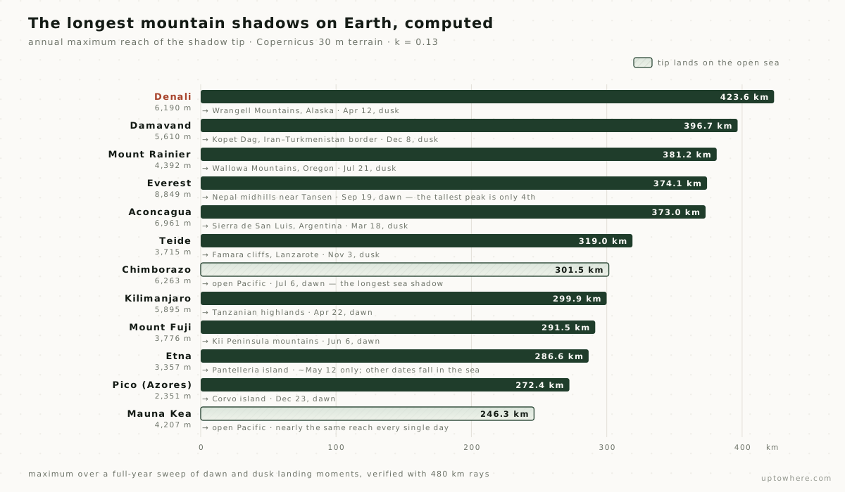
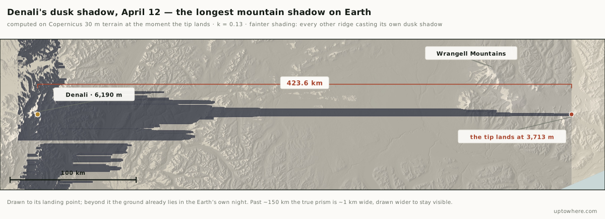
The longest mountain shadow on Earth belongs to Denali. On April 12, at dusk, the summit's shadow crosses the entire Alaskan interior and lands 423.6 km away on the high flanks of the Wrangell Mountains, at 3,713 m: one great massif shading another across a whole subcontinent of forest. Nothing else we tested comes within fifty kilometres.
Second place is the one nobody would have guessed: Damavand, Iran's 5,610 m stratovolcano, whose December dusk shadow runs 396.7 km northeast across the Alborz and lands in the Kopet Dag hills on the Iran–Turkmenistan border.
Third is Mount Rainier, and it comes with the most usable date on the whole list. Its longest shadow of the year, 381.2 km, falls at dusk on July 21, a midsummer evening in the Pacific Northwest, when the shadow crosses the entire Columbia Basin and climbs the Wallowa Mountains in northeastern Oregon. It happens within a day or two of that date every July, which makes it the one entry here you can actually put in a calendar.
And here is the second myth down: Everest is fourth. Its best shadow of the year (374.1 km, a September dawn, landing in Nepal's midhills near Tansen) is shorter than Denali's, Damavand's and Rainier's, despite Everest standing 2,700 to 4,500 metres taller than all three. The reasons are Everest's own neighbourhood: its shadow lands on terrain that is itself kilometres high, so the geometry that would let a ray glide to the horizon gets intercepted early. And its eastern skyline of 8,000 m peaks delays first light, costing the shadow its longest moments. Height helps a shadow. An empty stage helps it more.
Fifth is Aconcagua, and it makes the same point from the other hemisphere. Its equinox-dusk shadow runs 373.0 km due east across the Andean foothills into Argentina's Sierra de San Luis, at 1,661 m: within five kilometres of Everest's mark, off a peak more than 1,800 m shorter, because the pampas beyond it are as empty a stage as Denali's Alaska.
The special prizes: Chimborazo owns the longest shadow over open water: 301.5 km of July dawn shadow laid flat across the Pacific, the largest sea shadow we found anywhere (sorry, Tenerife). And Mauna Kea is the metronome: an island volcano in an empty ocean, its shadow lands between 230 and 246 km at almost every single dawn and dusk of the year, the most reliable giant shadow on the planet.
Teide: the legend undersells it
So where does that leave the mountain with the official "world's largest shadow" title? Sixth by raw distance, and holder of the strangest record of all.
Start with the famous claim. The plaques say the shadow reaches La Gomera, forty kilometres out. Our full-year sweep says the shortest interesting thing Teide's shadow does is reach La Gomera. From April 5 to September 7, every clear morning, the newborn tip touches down far beyond the island and sweeps across it as it retreats: on an August morning we modelled, the tip lands ~93 km out, overshooting La Gomera by thirty kilometres, then crosses the whole island in minutes on its way home. The "40 km shadow" is not the record; it's the aftermath.
The real Teide record needs a calendar, not a tape measure:
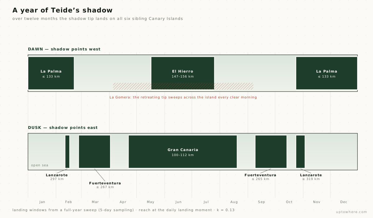
Follow it through the year. Winter dawns throw the shadow northwest onto La Palma, where it climbs to 2,400 m, high enough to brush the Roque de los Muchachos observatory. Summer dawns pivot the axis southwest onto El Hierro, 147 km out. In between, all drape-season long, the tip sweeps La Gomera daily. Evenings run the other way: Gran Canaria all summer (the shadow lands on the slopes below Pico de las Nieves), Fuerteventura through spring and autumn at up to 267 km, and for a few days in February and around November 3, the year's longest throw: 319 km to the Famara cliffs of Lanzarote.
Count them: La Palma, La Gomera, El Hierro, Gran Canaria, Fuerteventura, Lanzarote. Over one year, Teide's shadow lands on every other main island of the Canary archipelago. No other mountain shadow on Earth performs anything like that circuit. Teide's true title isn't "largest"; it's the only shadow with an itinerary.
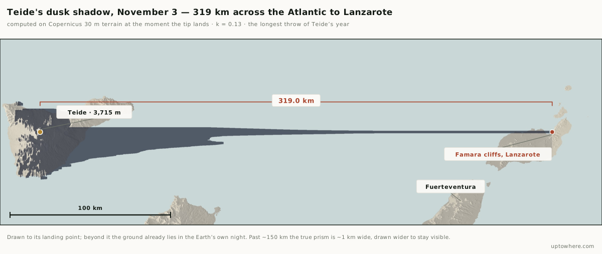
That November evening is worth picturing properly. The shadow leaves Tenerife as a wedge tens of kilometres wide, thins as it crosses the open Atlantic, and by the time it reaches Lanzarote the prism is barely a kilometre across: a dark blade laid over 300 km of water, aimed at a cliff.
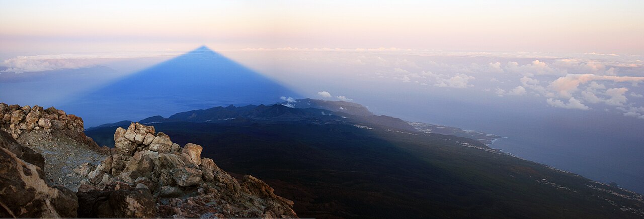
Photo: Andys, CC BY 3.0, via Wikimedia Commons.

The island snipers
Teide isn't the only mountain whose shadow hunts islands, just the only one that bags the whole set. Two others pull off single spectacular strikes, each within a narrow calendar window:
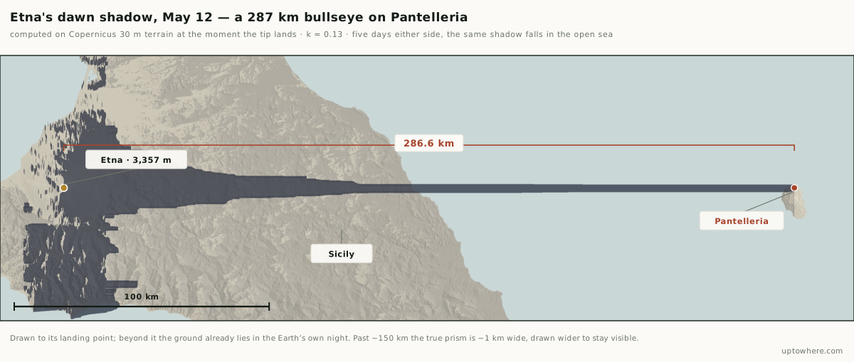
- Etna → Pantelleria. For about one week a year, around May 12, Etna's dawn shadow crosses all of Sicily, the Sicilian Channel, and lands 286.6 km away on the island of Pantelleria, halfway to Tunisia. Five days earlier or later, the azimuth has moved on and the shadow falls harmlessly into the sea at ~210 km. A 287-kilometre bullseye on a 14-kilometre-wide target, open a few mornings a year.
- Pico → Corvo. In deep December, dawn shadow from Pico in the Azores reaches 272.4 km northwest and lands on Corvo, the smallest island of the archipelago, 6 km across. For the rest of the year: open Atlantic.
- Kilimanjaro → Meru. Africa's roof plays a nearer game: its dawn shadow axis crosses Mount Meru, 70.6 km west, in two windows (April 27 to May 14 and July 29 to August 15) when climbers summiting Kibo at sunrise watch the pyramid's point ride straight over its neighbour volcano.
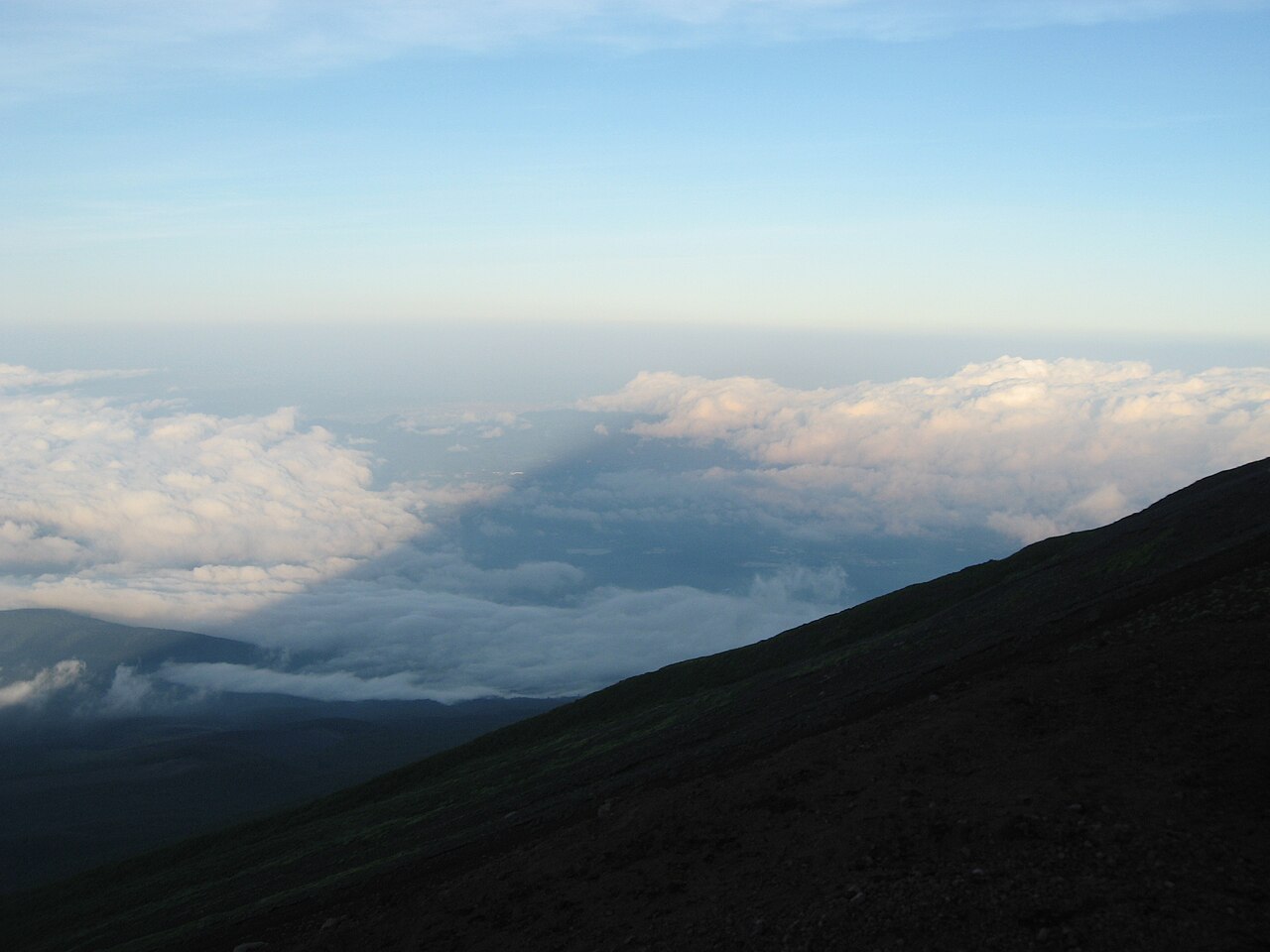
Photo: Koichi Shibata, CC BY-SA 3.0, via Wikimedia Commons.

The shadow that lands on the sky
One famous shadow refuses to obey the ground rules. Mount Rainier's most photographed trick isn't its 381 km ground shadow. It's the shadow it paints on the sky:
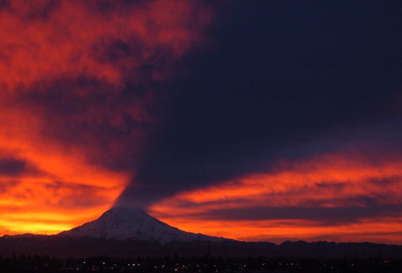
Photo: Troymason, CC BY 2.0, via Wikimedia Commons.

The geometry is the birth-of-the-tip story again, seen from below. Before the grazing ray can land on terrain, it spends long minutes airborne, and if a high cloud or haze layer hangs in that airspace, the shadow prism prints on it from underneath. Seattle sees this on winter mornings when the sun rises south of east, the shadow flies northwest, and the city's cloud ceiling becomes a screen. The "impossible" upward shadow is just a sky-shadow: the part of the prism that hasn't landed yet.
How the numbers were made
The model: rays travel over a sphere of effective radius R′ = R/(1 − k) with k = 0.13, the standard refraction the whole site uses; terrain is Copernicus GLO-30 (30 m). For each event we find terrain-aware first light (apparent sun altitude vs the computed horizon profile per half-degree of azimuth), then march the anti-sun grazing ray from the summit in 100 m steps, z(d) = h − d·tan(a) + d²/2R′, and record the first terrain intersection beyond the mountain's own cone. The landing moment is bisected to ~2 s. Year sweeps run every 5 days, dawn and dusk; all results ≥ 290 km were re-verified with 480 km rays, which corrected several: longer rays can reveal an earlier landing on farther terrain (that pass alone promoted Denali from 357 to 423.6 km and Damavand from 353 to 396.7 km). Summit heights come from the DEM itself, which reads a summit pixel a little low on sharp peaks (Everest samples at 8,733 m against the surveyed 8,849 m), a conservative choice: the true shadows are, if anything, slightly longer. Cloud, haze and the sun's half-degree width are not modelled; they soften the tip in reality, which is why a 424 km shadow is a geometric fact but not a photograph.
Find the horizon your own shadow falls over
A shadow at first light is a sightline wearing a disguise. The tip can only land where the summit can see, at a grazing angle, which is why this whole study is a line-of-sight computation, and why the number that decides a shadow's reach is the same one that decides your view: how far the terrain lets you see before the Earth bends away.
That part you can run yourself, in seconds, for anywhere on Earth:
- Compute a 360° viewshed from any summit, ridge or window and get the farthest visible terrain in every direction: the same ring a shadow tip would be born on at dawn.
- Use point-to-point mode to test one specific line, with curvature, refraction and the exact blocking ridge named.
- Or browse 162 famous viewpoints already computed, including Teide, Mount Rainier and Everest.
See how far you can see from any point on Earth, free
And to catch a shadow in person, no computation required: any high summit, any clear dawn, the first twenty minutes after first light. Stand on top and watch the triangle assemble itself out of the retreating night, then collapse toward you faster than any aircraft flies.
Frequently asked questions
Can you actually see a 400 km shadow?
Not from the ground, and not as a crisp edge. Near the tip, the sun is barely occulted by a distant summit and the penumbra is many kilometres wide; haze usually erases the last stretch entirely. What you can see is the triangle from the summit (the first ~100 km of it, on a clear morning) and the tip's sweep across nearby terrain: the La Gomera drape is real and photographed constantly. The 423.6 km figure is the geometric reach of the umbra's centreline, which is the honest way to compare mountains, not a claim about what your eyes resolve.
Why isn't Everest's shadow the longest, if it's the tallest mountain?
Because a shadow's reach depends on the drop from the summit to whatever the shadow lands on, and on how empty the land beyond is. Everest's shadow falls on the Himalaya and the Tibetan margin: terrain that is itself two to five kilometres high, which intercepts the grazing ray early. Denali stands 5,600 m above the low interior of Alaska with essentially nothing in the way for four hundred kilometres. Everest also loses its longest moments to its neighbours: Makalu and Kangchenjunga raise its eastern horizon and delay first light by over a degree of sun altitude.
When is the best time to see Teide's shadow?
Any clear sunrise or sunset from the summit area (the cable car's first runs catch it in summer). For the full spectacle, the twenty minutes after first light: the shadow starts as a wall of night, grows a tip at the horizon, and collapses inward. Between April and early September the morning axis crosses La Gomera; in late October and early November the evening shadow makes its longest throw of the year, up to 319 km toward Lanzarote.
Does the shadow tip really move at nearly 3,000 km/h?
On average over its first two minutes at Teide, yes: 215.8 km to ~120 km, an average of nearly 2,900 km/h. At the instant of birth its speed is formally unbounded (the tip appears "from infinity" at the horizon and decelerates as the sun climbs): in the first ten seconds alone it covers nearly 27 km, over 9,000 km/h. Nothing physical is moving at that speed: it's the intersection point of a light boundary with the ground, which is allowed to outrun aircraft, sound, and anything else.
Is Teide's "largest shadow in the world" claim true or false?
As stated ("the largest shadow projected over the sea") it's beaten by Chimborazo's 301.5 km Pacific landing, and by raw reach Teide sits sixth of our twelve. But the legend undersells the real phenomenon: no other mountain's shadow visits six islands in a year, and none is watched by more people from inside the shadow cone itself. Wrong superlative, right mountain.