UpToWhere
What can you see from Pico Veleta?
Its old summit road was once the highest paved route in all of Europe.
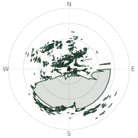
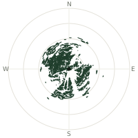
From Pico Veleta, the terrain-limited line of sight reaches up to 334 km. The single farthest piece of visible terrain lies 334 km to the southeast (bearing 139°), at 1,436 m elevation. These results account for Earth's curvature and standard atmospheric refraction, computed from 30-meter resolution Copernicus GLO-30 elevation data across 2,385,124 terrain samples.
Open the interactive visibility map →Visibility by direction
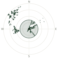
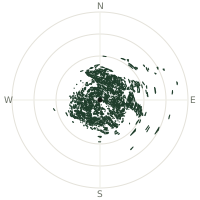
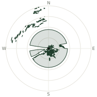
The horizon is most open toward the southeast, where sightlines run 296 km on average; terrain closes the view down fastest to the east, at 12.3 km.
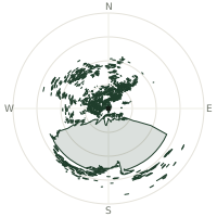
| N | 154 km | |
| NNE | 143 km | |
| NE | 131 km | |
| ENE | 70.1 km | |
| E | 12.3 km | |
| ESE | 138 km | |
| SE | 296 km | |
| SSE | 284 km | |
| S | 248 km | |
| SSW | 259 km | |
| SW | 257 km | |
| WSW | 191 km | |
| W | 163 km | |
| WNW | 238 km | |
| NW | 198 km | |
| NNW | 176 km |
Farthest named landmarks in view
1,168 named peaks, hills and headlands stand inside this viewshed. These are the farthest ones you could pick out on a clear day:
| Landmark | Visible distance | Direction | Elevation |
|---|---|---|---|
| Djebel es Sat | 333 km | SE · 138° | 1,353 m |
| Djebel Somsal | 333 km | SE · 139° | 1,438 m |
| Toumzayet | 327 km | SSE · 151° | 1,797 m |
| Djebel ed Demamene | 320 km | SE · 141° | 1,413 m |
| Djebel Miez | 319 km | SE · 139° | 1,119 m |
| Temâsskhet | 316 km | SSE · 148° | 1,395 m |
About Pico Veleta
Pico Veleta, at 3,396 metres, is the second-highest peak of the Sierra Nevada, and the road that once climbed almost to its top was, for decades, the highest paved road in Europe. Since 1984 its upper slopes have hosted the IRAM 30-metre telescope, one of the world's most sensitive instruments for observing radio waves from deep space, sited there for the exceptionally thin, dry air. The old summit road is now closed to general traffic above the ski station, though hikers, cyclists, and observatory staff still use it to reach the top.
Did you know?
- Snow can block the upper switchbacks of the old summit road well into June, even as the ski station just below fills with summer hikers and mountain bikers.
- The IRAM 30-metre telescope on its slopes, installed in 1984, is one of the most powerful millimetre-wave radio telescopes on Earth.
- Veleta rises above one of the southernmost ski resorts in Europe, where snow and Mediterranean beach weather sit barely an hour apart.
- From the summit, the Mediterranean coastline near Motril is visible to the south, well below the Sierra Nevada's ski slopes.
- Veleta is separated from Mulhacén, Spain's highest peak, by a high ridge that hikers cross to link both summits.
Frequently asked questions
How far can you see from Pico Veleta?
On a clear day the terrain allows a line of sight of up to 334 km from Pico Veleta. The average visible distance across all 360 directions is 185 km. Atmospheric conditions (haze, humidity) usually reduce practical visibility below the terrain-limited maximum.
What is the farthest point visible from Pico Veleta?
The farthest terrain visible from Pico Veleta lies 334 km to the southeast, at an elevation of 1,436 m. Earth's curvature and atmospheric refraction are accounted for in this calculation.
How high is Pico Veleta?
The observation point at Pico Veleta sits at 3,390 m above sea level (Copernicus GLO-30 elevation model).
How is this visibility map calculated?
UpToWhere traces lines of sight in 360 directions from the observer using 30 m-resolution Copernicus terrain data, correcting for Earth curvature and standard atmospheric refraction. You can run the same analysis for any point on Earth with the free calculator.
Run your own analysis
Want to know what you can see from your house, a summit you're planning to climb, or a plot of land? UpToWhere computes the same 360° viewshed for any point on Earth in seconds — free.
Try the viewshed calculator