 UpToWhere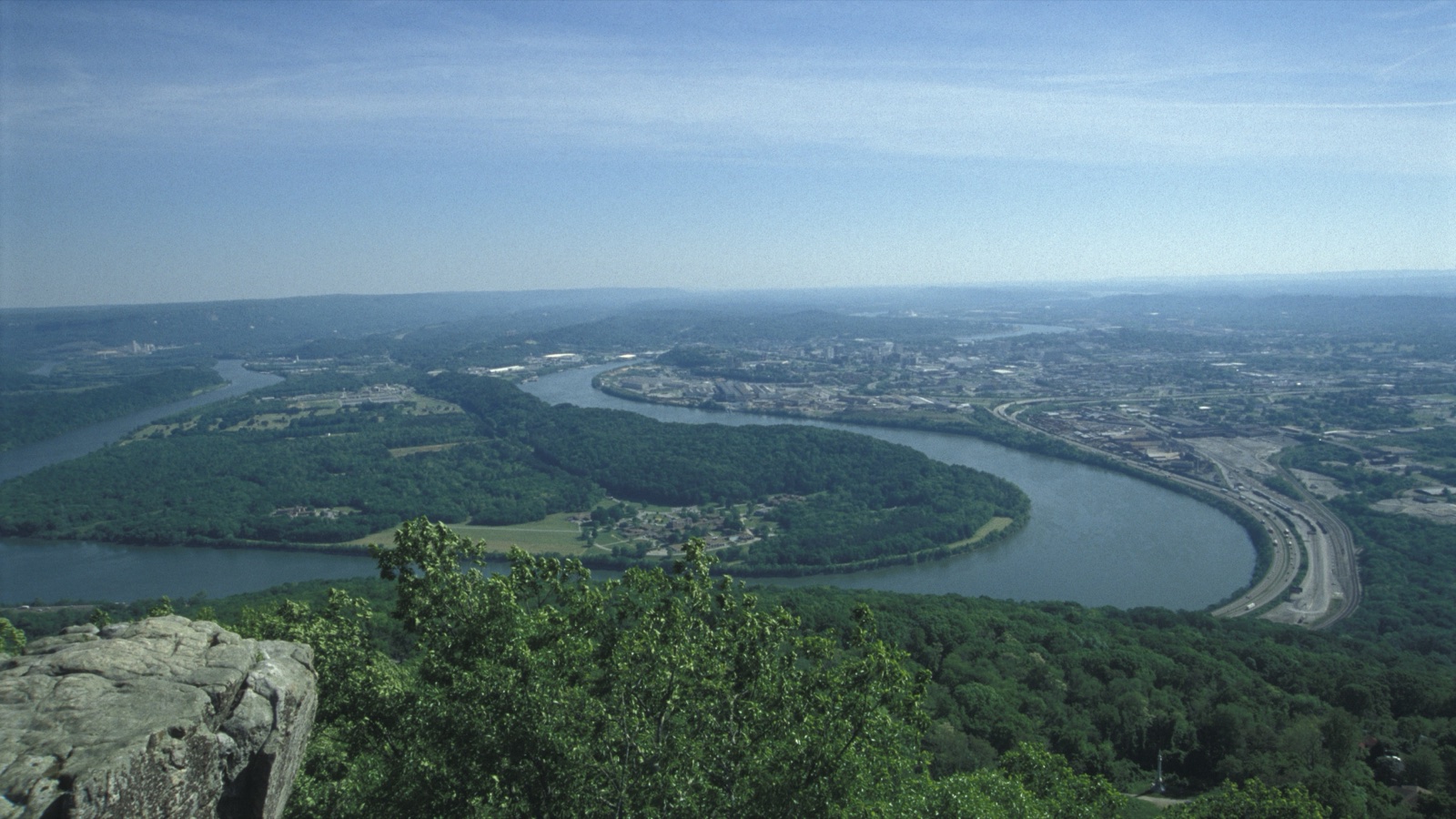
Photo: Torsten Henning, public domain, via Wikimedia Commons.

There is a rock at Rock City Gardens, on the Georgia side of Lookout Mountain, with a metal marker bolted to it. The marker gives a compass rose and, for each of six distant states, a distance in miles: "Tenn. ½ MI.; KY-VA 120 MI Mt Pinnacle; N.C. 50 MI. Smoky Mts.; S.C. 80 MI.; Georgia; ALA. 25 MI."
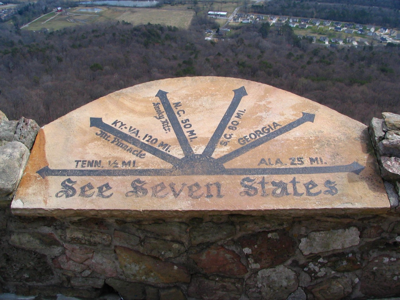
Photo: Brent Moore, CC BY 2.0, via Wikimedia Commons.

Rock City has been selling this view since it opened on May 21, 1932. The claim itself is older. Frieda Carter's garden trail was built to end at this outcrop, called Lover's Leap, because Civil War soldiers had already made the story famous: during the 1863 Battle of Lookout Mountain, a Union officer and a Confederate nurse each wrote in their diaries, independently, that seven states were visible from the summit. In the 163 years since, Wikipedia notes dryly, "no scientific investigation has upheld this claim."
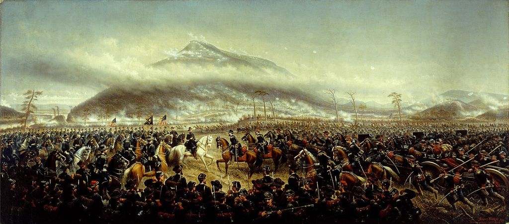
Painting: James Walker, 1874, public domain, via Wikimedia Commons.
.jpg)
People have certainly argued about it. The site carries two separate historical markers, one asserting the view and another, "Do You See 7 States?", that reads more like a dare. Tripadvisor hosts reviews titled "You really can't see seven states" where visitors run back-of-envelope trigonometry at each other. In 2007 a University of Tennessee scientist, asked to referee, shrugged that the claim meant seeing high points in those states and predated modern smog, adding "I never thought it significant." What nobody ever did was run the terrain.
So we ran all of it.
What we ran
Everything below comes out of the same engine that powers UpToWhere, working on 30 m Copernicus elevation data with Earth's curvature and standard atmospheric refraction (k = 0.13) in the geometry. Starting from the marker's exact coordinates (34.9736° N, 85.3477° W, 499 m elevation, eye height 1.7 m) we computed:
- 720 full sightlines from the marker, one every half degree of bearing, each traced out to 300 km, keeping every visible terrain sample along the way. Then we assigned each of those 44,621 samples to a state using Census high-resolution boundaries.
- A composite viewshed of the whole mountaintop. A single overlook can sit behind a local rise, so we didn't stop at the marker. We repeated the 360° analysis from a grid of 20 points spanning the accessible north end of Lookout Mountain (both brows, from Rock City up to the Point Park battlefield) and unioned the results, to ask the fair question: from anywhere a visitor can stand up there, what can actually be seen?
- Point-to-point verdicts for every landmark the marker itself names: Pinnacle Overlook at Cumberland Gap for the fused "KY-VA" entry (it stands about 500 m from the spot where Kentucky, Virginia and Tennessee meet), Clingmans Dome for "Smoky Mts.", Mentone for Alabama, plus the two best candidates South Carolina has to offer, since the marker names none: Ellicott Rock, the exact GA-NC-SC corner, and Sassafras Mountain, the state's high point.
- A refraction sweep on each blocked sightline, from k = 0 (no refraction at all) to k = 0.9 (absurd), to see whether any verdict is weather-dependent.
- Control runs to make sure the answer isn't an artifact of one DEM cell: the same analysis from the mountain's true 729 m summit (High Point, a few miles south), from the highest knoll inside the gardens, and with a taller observer.
Where the view actually lands
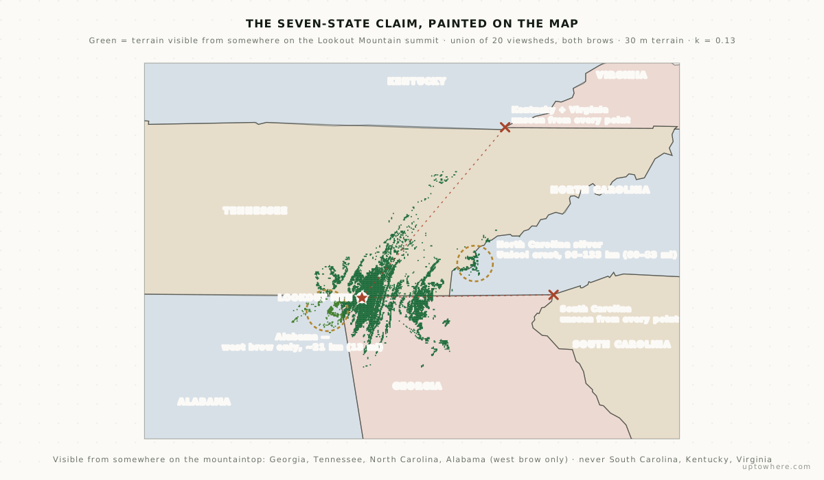
Green is every piece of ground visible from somewhere on the accessible north end of Lookout Mountain: the union of viewsheds computed from 20 points spanning both brows, from Rock City up to the Point Park battlefield. It lands in four states:
- Georgia and Tennessee, the near ground: the Chattanooga valley underfoot, Walden Ridge across it, and long fingers reaching up the Tennessee Valley. The single longest sightline of the whole set runs 156.6 km (97 mi) northeast to the crest of the Cumberland Mountains above Oliver Springs, the ridge that now holds Windrock Park, beyond Oak Ridge. To the southeast it reaches Mount Oglethorpe, 107 km (67 mi) off in Georgia, the original southern terminus of the Appalachian Trail, where from 1937 to 1958 every thru-hike began or ended.
- North Carolina, a thin, broken sliver of the Unicoi crest 96 to 133 km (60–83 mi) east, where the state line happens to ride the ridgetop past Huckleberry Knob (1,690 m, the roof of the Unicois). Not the Smokies the marker points at: those stay hidden, or very nearly (more below).
- Alabama, but not from the marker. It shows up from the western brow of the plateau (the side that faces the Lookout Valley) and from the highest ground at the north end; the nearest visible Alabama is about 21 km (13 mi) southwest, up on Sand Mountain. From the eastern brow, where the famous marker sits, Alabama is behind you and invisible. That one state is the entire difference between the marketed overlook and the mountain as a whole.
Three states never appear at all. South Carolina, Kentucky and Virginia show up in not one of the twenty viewsheds: blocked by real terrain, by margins of one to three kilometres, in any atmosphere.
So the honest count has two numbers. From the marketed marker on Lover's Leap: three. From the whole accessible mountain: four. Never the promised seven, and never more than four.
The marker's own spot is the stingy one, and the reason is which way it faces. Lover's Leap sits on the east brow, so its view is a one-sided fan: enormous to the east, dead to the west, where you are looking back across the plateau you stand on. Ahead of the marker the ground falls 300 m into the valley and the sightlines run for a hundred kilometres and more; behind it, the view dies within 3 km (2 mi) against the rest of the mountain. This lopsidedness is stable: raising the eye to 3 m or hopping to the highest knoll in the gardens barely changes it. But cross the plateau to the far brow, about a kilometre west, and the fan flips: now it looks out over the Lookout Valley, and Alabama's Sand Mountain rises into view. That short walk is worth a whole state, which is the crux of the whole legend.
A view that big, that hazy, and that unlabelled will happily support any story told about it. Here is what each of the marker's seven claims is actually worth.
The verdict, state by state
| State | Marker says | From the marker (Lover's Leap) | From the whole mountaintop |
|---|---|---|---|
| Georgia | – | Visible: you're standing in it | Visible |
| Tennessee | ½ mi | Visible: Chattanooga in plain sight | Visible |
| North Carolina | 50 mi, "Smoky Mts." | Visible, barely: a Unicoi-crest sliver | Visible (same sliver) |
| Alabama | 25 mi | Blocked: it's directly behind you | Visible from the west brow, ~21 km SW |
| South Carolina | 80 mi | Blocked: misses by 3.0 km | Never: unseen from every point |
| Kentucky | 120 mi, "Mt Pinnacle" | Blocked: misses by 1.9 km | Never |
| Virginia | (same entry) | Blocked: misses by 1.9 km | Never |
Three from the marker, four from the mountain. The 1930s sign painter got Georgia, Tennessee and North Carolina right from the overlook, missed Alabama only by facing the wrong way, and was simply wrong about the last three: no spot on the mountain sees South Carolina, Kentucky or Virginia. The rest of this piece walks each of those verdicts.
Kentucky and Virginia die 27 miles in
The marker's boldest entry sends your eye 120 miles to "Mt Pinnacle," the overlook above Cumberland Gap where Kentucky, Virginia and Tennessee meet. The real distance is 147 miles, and the sightline doesn't come close to going that far:
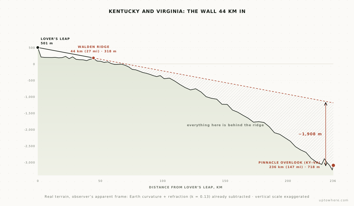
Walden Ridge, the eastern escarpment of the Cumberland Plateau, crosses the line 44 km (27 mi) out at a modest 318 m. That is all it takes. Once a sightline grazes a ridge it becomes a fixed ray, and the ground it needs to reach 190 km (118 mi) further on keeps sinking below the horizon as the planet curves away. By Cumberland Gap the terrain sits 1,908 m under the ray. The refraction sweep makes the verdict final: even at k = 0.9, a value real air does not produce, the gap still misses by 19 m. There is no atmosphere, on any day in history, through which Lover's Leap has seen Kentucky or Virginia. And moving around the mountaintop doesn't rescue it, either: the best of the twenty plateau points still falls 1.4 km (0.9 mi) short.
North Carolina is visible. The marker just points at the wrong mountains
The marker says "N.C. 50 MI. Smoky Mts." Both halves of that entry fail: the nearest visible North Carolina ground is 60 miles out, and it isn't the Smokies. Clingmans Dome, the Smokies' 2,025 m summit and the most conspicuous NC target on the horizon-that-would-be, hides behind the front crest of the Unicoi Mountains:
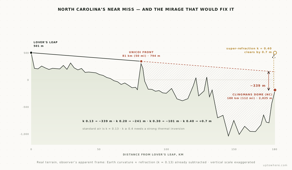
This one is the study's near miss, and it has a twist. The miss at standard refraction is 339 m. Walk the refraction coefficient upward, the kind of thing a strong temperature inversion over a cold valley does to light, and the gap closes: 241 m at k = 0.20, 101 m at k = 0.30, and at k = 0.40 the summit clears the Unicoi crest by 0.7 m. Under a serious inversion, the top of the Smokies could in principle shimmer above the ridge from Rock City, in the way Joshua Nowicki's famous photographs put Chicago's skyline above Lake Michigan. Nobody seems to have ever photographed it. Consider that a standing challenge for a cold, still November morning.
But North Carolina does not need the mirage, because of a quirk the sign never mentions: for 36 km the state border runs along the very crest of the Unicois, and slivers of that crest clear every obstacle. Huckleberry Knob and its neighbors put a thin strip of genuine North Carolina into the view on an ordinary clear day. We classified those samples against high-resolution state boundaries precisely because the crest and the border coincide; about half the candidate cells turned out to be Tennessee-side and were discarded. It is the thinnest possible way for a state to make the list. It counts.
And the composite adds one more wrinkle. Clingmans Dome is blocked by 339 m from the marker, but from the higher north end of the mountain, near Point Park, the very tip of the Smokies' summit actually clears the Unicoi crest by under a metre at ordinary refraction. So even the Smokies flicker in and out depending on exactly which overlook you're standing on, which is a fair summary of this whole mountain.
South Carolina never had a chance
South Carolina gets "80 MI." and no landmark, so we gave it every advantage. Its nearest soil of any kind is Ellicott Rock, the surveyed point where Georgia, North Carolina and South Carolina touch, 127 miles away in the Chattooga gorge: blocked by the Rabun County highlands of northeast Georgia, 3,022 m below the grazing ray. Its tallest asset, Sassafras Mountain, does even worse at 4,103 m under. At k = 0.9 the misses are still measured in kilometers, and the best of the twenty plateau points still falls 2.8 km (1.7 mi) short. Of the three states you can never see from up here, this is the least ambiguous. The reviewer who likened the flag court to "standing on the beach with a sign that points to countries across the ocean" had South Carolina dead to rights.
Alabama: behind the mountain, until you cross it
Alabama is the one verdict that flips, and it's the most interesting result in the study. The marker says "ALA. 25 MI." and points southwest, and from Lover's Leap that direction is hopeless. You are on the east brow, and Alabama sits behind the entire width of the plateau you're standing on. In the marker's own 720-ray panorama, not one visible sample lands in Alabama; the sightline toward Mentone runs straight into the mountain's own rising crest within the first kilometre. Even from High Point, the mountain's true 729 m summit, Mentone still misses by 96 m.
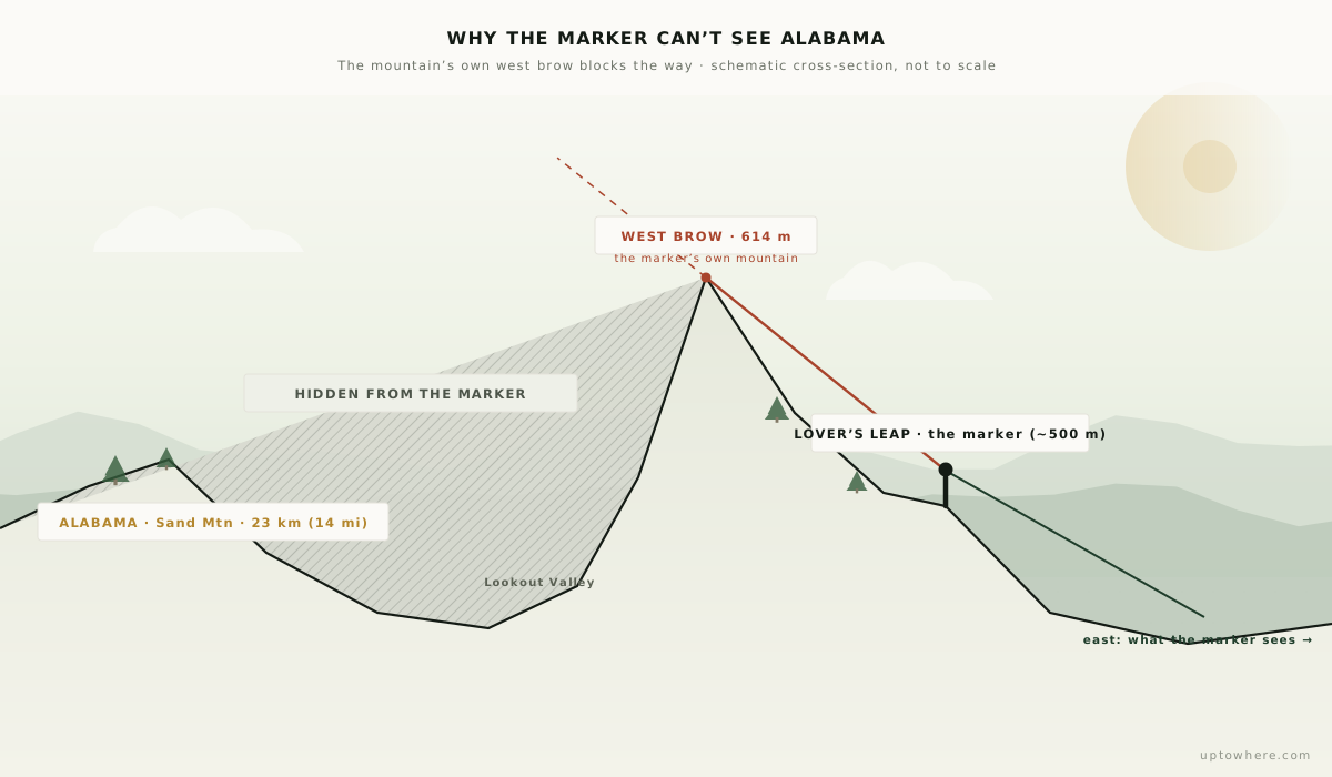
But a mountain has two edges. Walk about a kilometre west, to the brow above the Lookout Valley, and the ground finally falls away toward Alabama instead of rising toward the gardens. Six of our twenty plateau points see Alabama: four along that western brow, the other two from the highest ground at the north end near Point Park, where sheer elevation clears the plateau. Not one of them is the marker. The nearest visible Alabama is about 21 km (13 mi) southwest, up on Sand Mountain across the valley. (The valley floor and the low tri-state corner down by the Tennessee River stay hidden behind Sand Mountain's own rim; what you catch is the Alabama plateau beyond it.) It isn't much, and it isn't from the rock with the sign on it, but it is unambiguously Alabama. The state the marker prices at 25 miles is real. It's just on the other side of the mountain from the marker that promises it.
This is also the honest answer to the obvious objection: maybe the single overlook is just unlucky. It is. Moving the observer around the mountaintop is exactly what turns three states into four. It does not turn four into five: the western brow that adds Alabama still can't reach South Carolina, Kentucky or Virginia, and neither can anywhere else up there.
The sign's own arithmetic
Set visibility aside and just grade the engraved distances against a modern map. "KY-VA 120 MI" is really 147. South Carolina's "80 MI." is really 127 to the nearest inch of the state. And "N.C. 50 MI. Smoky Mts." is the worst of the lot: the Smokies are 112 miles off, and even the nearest visible North Carolina dirt is 60. Those three distant states are all undersold, by a fifth to more than double. Whoever laid out the marker in the 1930s measured a paper map optimistically and nobody in ninety years of half-a-million annual visitors seems to have re-measured. Tennessee's "½ MI." is the one entry that survives contact with a ruler, which is fitting, because it is also the one distant-state claim that survives contact with the terrain from the marker.
None of this dented the marketing. Garnet Carter hired sign painter Clark Byers to paint "SEE ROCK CITY" across barn roofs from Michigan to Texas; hundreds still stand, and the seven-state promise rode north and west with them, one black-and-white roof at a time. A view is a hard thing to fact-check from a highway in Indiana.
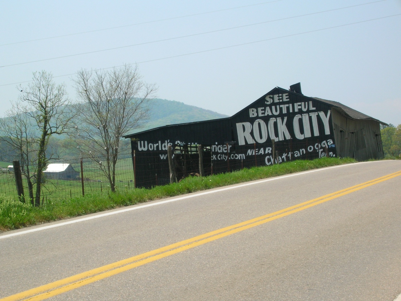
Photo: Scott Basford, CC BY-SA 3.0, via Wikimedia Commons.

Could the soldiers of 1863 have counted seven?
The diary writers stood on other parts of the mountain, in pre-industrial air. Does that rescue them? Not to seven. The refraction sweep shows Kentucky, Virginia and South Carolina are blocked by rock, in any air, from every one of the twenty points we tested. But the composite is exactly what shows how the legend got its plausibility: move a few hundred metres along the brow and windows open and close. Chattanooga fills one overlook and vanishes from the next; cross to the far edge and a whole new state, Alabama, swings into view. Two people on the same mountain in 1863, pointing at different hazy ridges with no way to check, would honestly have come home with different counts, and the true ceiling, four, already takes a walk from one side of the mountain to the other. Seven was always the more marketable number, and it's the one that got the marker.
How the numbers were made
A viewshed is a line-of-sight problem run in every direction at once. From a point, the engine fans out hundreds of rays (720 from the marker, one every half a degree) and walks each one outward across the 30 m Copernicus elevation model, sample by sample, keeping track of the steepest upward angle it has seen so far. Terrain that doesn't rise above that running angle is hidden behind something closer. Earth's curvature and standard atmospheric refraction (k = 0.13, the gentle downward bend of light through still air) are baked into the geometry, because both matter long before 50 km (31 mi): draw this on a flat map and you'd wrongly "see" half of Kentucky.
What keeps it honest is that we never trusted a single point. One overlook can sit in the shadow of a boulder, a treeline, or (as here) the rest of its own mountain, and quietly lose a whole state. So we repeated the full 360° computation from twenty observer points spread across the accessible top of Lookout Mountain's north end, both brows, 360 rays apiece, from the Rock City overlook up to Point Park, then combined them: a patch of ground counts as visible if any of the twenty can see it. That union is what moves Alabama from "invisible" (true only of the east-facing marker) to "visible" from the western edge, and it's what lets us say the opposite about South Carolina, Kentucky and Virginia with real confidence: not one of the twenty catches a single cell of them.
Turning "visible terrain" into "which state" is a second pass: every visible sample is tested against high-resolution Census state outlines, point in polygon. That care matters most for North Carolina, whose entire share is a ridgeline where the state border and the Unicoi crest run within metres of each other: a coarser boundary would hand half of it to Tennessee. And for every blocked target we swept the refraction from k = 0 to an absurd k = 0.9, to tell terrain blocked by rock (unchanged at any value) apart from terrain blocked only by ordinary air (the Smokies, which flip near k = 0.4). Every input is public (Copernicus GLO-30 elevation, Census boundaries), so the whole thing is reproducible.
Run your own legend
Every number in this article is a line-of-sight computation over public elevation data, the kind that took a survey crew weeks in 1932 and takes seconds now. If your region has its own version of the seven-states rock, a summit sign, a "you can see X from here" folk claim, an argument between two bar stools, it is now checkable:
- Run a 360° viewshed from the spot and see the whole reach of the view, with the farthest terrain in every direction.
- Use point-to-point mode to test the specific claim, with curvature, refraction and the exact blocking ridge named.
- Or browse 162 famous viewpoints we've already computed.
Check your own "you can see it from here" claim, free
Frequently asked questions
How many states can you actually see from Rock City?
Three from the exact "See Seven States" marker: Georgia (underfoot), Tennessee (starts half a mile away), and a thin sliver of North Carolina: the crest of the Unicoi Mountains 96 to 133 km east, where the state line follows the ridgetop. Count the whole accessible mountaintop and it's four: the western brow of the plateau, a short walk from the marker, adds Alabama. South Carolina, Kentucky and Virginia are blocked by intervening terrain from every point on the mountain, so seven is never reached.
Why can't you see Alabama from the marker, when it's the closest claimed state?
Because Lover's Leap faces the wrong way. The marker is on the east brow of Lookout Mountain and Alabama lies west, behind the plateau itself: the sightline runs into the mountain's own rising crest almost immediately, and that holds even from the 729 m summit. But walk about a kilometre to the western brow, above the Lookout Valley, and Alabama comes into view roughly 21 km (13 mi) southwest, on Sand Mountain. It's the one state whose visibility depends entirely on which edge of the mountain you stand on.
Could unusual weather ever add a state to the view?
The fourth state, Alabama, needs no weather: just the west brow. Beyond that, only the Smokies are close to the edge: Clingmans Dome misses by 339 m from the marker under standard refraction and would clear at about k = 0.40 (a strong temperature inversion), and it already barely clears from the higher north end of the mountain. South Carolina, Kentucky and Virginia stay blocked even at physically absurd refraction values, so five states are out of reach in any atmosphere.
Where does the seven-states story come from?
From the 1863 Battle of Lookout Mountain, when a Union officer and a Confederate nurse independently wrote in their diaries that seven states were visible from the summit. Rock City, opened in 1932 by Garnet and Frieda Carter and advertised on barn roofs across the country, built its marker and flag court around the story. No investigation had ever tested it against terrain data.
How was this computed?
By tracing sightlines over the Copernicus GLO-30 elevation model with Earth's curvature and atmospheric refraction applied: 720 rays from the marker, a composite union of 360° viewsheds from 20 points spanning both brows of the mountain's north end, direct point-to-point runs to every landmark the marker names, and a refraction sweep on each blocked sightline. Visible terrain was then assigned to states using high-resolution Census boundaries. UpToWhere runs the same computation for any point on Earth.